Round Top Branch
| Round Top Branch | |
| Round Top Extension | |
| railroad line | |
|
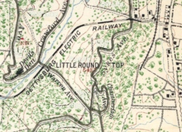
The Round Top Branch terminus (right, north-to-south) was south of Round Top, Pennsylvania and east of the Little Round Top summit.
|
|
| Country | United States |
|---|---|
| State | Pennsylvania |
| Region | Adams County |
| Municipality | Cumberland Township |
| Part of | G. & H. R. R. |
| Length | 2.798 mi (5 km) |
| Began | 1884 |
|
|
The Round Top Branch was an extension of the Gettysburg and Harrisburg Railroad from the Gettysburg borough across the Gettysburg Battlefield to Round Top, Pennsylvania. The branch ran southward from the terminus of the railroad's main line (its junction with the Hanover Junction, Hanover and Gettysburg Railroad north of Meade School), west of the school and St. Francis Xavier Cemetery, across the field of Pickett's Charge, south of Cemetery Ridge, east of Weikert Hill and Munshower Knoll, and through Round Top to a point between Little Round Top's east base and Taneytown Road. In addition to battlefield tourists, the line carried stone monoliths and statues for monuments during the battlefield's memorial association and commemorative eras and equipment, supplies and participants for Gettysburg Battlefield camps after the American Civil War (e.g., the 1884 Camp Gettysburg, 1913 Gettysburg reunion, 1918 Camp Colt and 1938 Gettysburg reunion).
After completion of a 22 mi (35 km) initial survey of Gettysburg along Rock Creek on January 12, 1882, the Gettysburg and Harrisburg Rail Roadmain line was instead completed into the borough along Oak Ridge with nine stations from Hunter's Run. By July 14, 1882, Ambrose E. Lehman of the State Geological Survey completed the G&HRR survey for the branch to Round Top, and the HJ,H&GRR (successor to the G&HRR) survey was begun by engineer Joseph S. Gitt for a competing Round-Top Railroad Company route to Round Top; the latter was never built.
...
Wikipedia

