Round Top, Pennsylvania
| Round Top | |
| Round-Top | |
| Unincorporated community | |
|
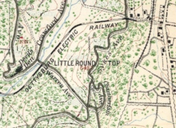
1904 map depicting Round Top buildings along the Taneytown and Wheatfield roads (right).
|
|
| Name origin: "Round-Top R. R. Station" | |
| Country | United States |
|---|---|
| State | Pennsylvania |
| County | Adams |
| Township | Cumberland |
| Borders on | Gettysburg National Military Park |
| Landmark | Round Top School House |
| - coordinates | 39°47′41″N 77°13′59″W / 39.794792°N 77.23305°WCoordinates: 39°47′41″N 77°13′59″W / 39.794792°N 77.23305°W |
| Established | c. 1880 |
| Timezone | EST (UTC-5) |
| - summer (DST) | EDT (UTC-4) |
| ZIP Code | 17325 |
| Area code | 717 |
| GNIS ID | 1185538 (1979) |
|
Round Top is between the Maryland/Pennsylvania state line and Gettysburg, Pennsylvania.
|
|
Round Top is a populated place in the U.S. state of Pennsylvania, near Little Round Top. It is notable for two Battle of Gettysburg hospitals, the 1884 Round Top Station, and several battlefield commemorative era attractions such as Round Top Park and the Round Top Museum. The unincorporated community lies on an elevated area of the north-south Taneytown Road with 3 intersections at Blacksmith Shop Road to the northeast, Wheatfield Road (west from "Roundtop"), and Sachs Road (east from "Sedgwick").
After an 1808 proposal, the Taneytown Road was constructed southward from Gettysburg past the east of the Round Tops and by 1858, 2 crossroads had been built to the area with 3 homes (north-to-south: "Geo Bishop", "E. Brickert", & "J. Group") that would become Round Top: Wheatfield Rd on the west across the north foot of Little Round Top to the Emmitsburg Road and Sachs Rd eastward across Rock Creek. In 1884, the Gettysburg and Harrisburg Railroad built a steamtrain railroad to the Round Top Station, which operated until c. 1942 when the branch's abandonment application was filed.[3] In 1894 on a different railway from the west, the Gettysburg Electric Railway began trolley operations to the station.
...
Wikipedia


