Rosewood, Saskatoon
| Rosewood | |
|---|---|
| Neighbourhood | |

Rosewood community plan
|
|
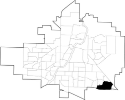
 Rosewood location map |
|
| Coordinates: 52°5′38″N 106°32′42″W / 52.09389°N 106.54500°WCoordinates: 52°5′38″N 106°32′42″W / 52.09389°N 106.54500°W | |
| Country |
|
| Province |
|
| City | Saskatoon |
| Suburban Development Area | Lakewood |
| Neighbourhood | Rosewood |
| Annexed | 1980-1984 |
| Construction | 2010 |
| Government | |
| • Type | Municipal (Ward 9) |
| • Administrative body | Saskatoon City Council |
| • Councillor | Bev Dubois |
| Area | |
| • Total | 2.93 km2 (1.13 sq mi) |
| Population (2011) | |
| • Total | 73 |
| • Average income | $104,964 |
| Time zone | UTC (UTC-6) |
| Website | www |
Rosewood is a primarily residential neighbourhood under construction in southeast Saskatoon, Saskatchewan, Canada. The majority of its residents live in single detached dwellings. In 2011, the area was home to 73 residents. I early 2015 there were approximately 900 occupied residences. The neighbourhood is considered a high-income area, with an average family income of $104,964, and a home ownership rate of 93.3%. According to MLS data, the average sale price of a home as of 2013 was $442,316.
The land where Rosewood is planned to exist was annexed between 1980 and 1984. It was considered challenging to develop - the area is dotted with sloughs and has a high water table. The majority of the wetlands were drained and filled with a single large wetland complex modified and used for drainage, eliminating the need for some storm sewer mains. Servicing of the land began in 2008, and home construction in the first phase of the community was underway in the summer of 2009.
The southwest corner of the community will consist of a commercial hub and multi-family dwellings, while a village square with businesses, parks and multi-family dwellings is planned for the centre of the neighbourhood. Housing will consist of 2731 single-unit dwellings and 1760 multi-unit condominium, townhouse and apartment dwellings. Between 2022 and 2025, Rosewood will reach completion and have an estimated population of 10,650. the city of Saskatoon has since updated the master plan eliminating a vital access point to highway 16, adding a large commercial property to the southeast and increasing density on the eastern portion of the subdivision by close to 50%. With a final estimated population exceeding 12,000.
Major access roads carry the Rosewood name, but street names assigned thus far by the city such as Ledingham, Rochelle, and Hastings, show no set pattern, other than to honour notable Saskatonians. One street name that attracted media attention when it was assigned in 2011 was Tweed Lane, named in honor of reality TV star, film actress and onetime Playboy Playmate of the Year Shannon Tweed, at the request of Tourism Saskatoon, which had honored Tweed with a faux street sign bearing the name in 2010.
A proposed amendment to the neighbourhood concept plan would add another 152 acres (62 ha) of land and 1200 people to the area. It incorporates a triangular piece of what was previously dubbed the Southeast Development Area. Originally it had been separated by a future perimeter highway, but in 2014 the alignment of the roadway was being reviewed, making the adjacent land available as an addition to the neighbourhood.
...
Wikipedia
