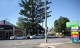
Rosewood, Queensland
|
Rosewood Ipswich, Queensland |
|||||||||||||
|---|---|---|---|---|---|---|---|---|---|---|---|---|---|
 |
|||||||||||||
| Coordinates | 27°38′S 152°35′E / 27.633°S 152.583°ECoordinates: 27°38′S 152°35′E / 27.633°S 152.583°E | ||||||||||||
| Population | 2,155 (2011 census) | ||||||||||||
| Postcode(s) | 4340 | ||||||||||||
| Location | |||||||||||||
| LGA(s) | City of Ipswich | ||||||||||||
| State electorate(s) | Ipswich West | ||||||||||||
| Federal Division(s) | Blair | ||||||||||||
|
|||||||||||||
Rosewood is a small town and locality in the Bremer Valley, Queensland, Australia. It is within the local government area of City of Ipswich.
The town of Rosewood is located 60 kilometres (37 mi) west of the Brisbane CBD At the 2011 census, Rosewood had a population of 2,155. Part of the town's border is marked by the Bremer River to the south, and the decommissioned Marburg Branch railway line on the Little Liverpool Range to the north.
The origin of the suburb name is believed to be derived from the Rosewood (Acacia harpophylla) or the Dysoxylum (a Mahogany species, referred locally as a rosewood despite bearing little relation) tree or shrub, both commonly found in the south-east Queensland region at the time of Rosewood's settlement.
The first coal mine in the Lanefield district, west of Rosewood, commenced production in 1918. As part of these workings, two railway branches from the Brisbane to Toowoomba main line were constructed to the mines at Lanefield Colliery (1934 to 1965) and Westvale Colliery (1929 to 1960).
The New Oakleigh Mine is located to the town's north and was one of the last remaining coal mines in the area at the time of its closure in 2013.
Rosewood is the terminus of Queensland Rail City network's Ipswich and Rosewood railway line. Rosewood railway station provides commuter rail services to Ipswich and Brisbane via Ipswich.
...
Wikipedia

