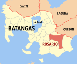
Rosario, Batangas
| Rosario | ||
|---|---|---|
| Municipality | ||

Downtown Rosario
|
||
|
||
| Nickname(s): Rice Granary of Batangas | ||
 Location within Batangas province |
||
| Location within the Philippines | ||
| Coordinates: 13°50′42″N 121°12′13″E / 13.845°N 121.2036°ECoordinates: 13°50′42″N 121°12′13″E / 13.845°N 121.2036°E | ||
| Country | Philippines | |
| Region | Calabarzon (Region IV-A) | |
| Province | Batangas | |
| District | 4th District | |
| Founded | 1687 | |
| Foundation Day | June 9 | |
| Feast | October 7 | |
| Barangays | 48 (see Barangays) | |
| Government | ||
| • Type | Sangguniang Bayan | |
| • Mayor | Manuel B. Alvarez (UNA) | |
| • Vice Mayor | Leovigildo K. Morpe (Liberal) | |
| Area | ||
| • Total | 226.88 km2 (87.60 sq mi) | |
| Population (2015 census) | ||
| • Total | 116,764 | |
| • Density | 510/km2 (1,300/sq mi) | |
| • Voter (2016) | 66,441 | |
| Time zone | PST (UTC+8) | |
| ZIP code | 4225 | |
| IDD : area code | +63 (0)43 | |
| Income class | 1st class | |
| PSGC | 041021000 | |
| Website | www |
|
Rosario, officially the Municipality of Rosario (Filipino: Bayan ng Rosario), is a municipality in the province of Batangas in the Calabarzon (Region IV-A) of the Philippines. The population was 116,764 at the 2015 census. In the 2016 electoral roll, it had 66,441 registered voters.
Rosario is considered as among the interior municipalities of the Batangas Bay Region comprising eleven municipalities and two cities whose catchment areas drain into the Batangas Bay. The town is also dubbed as "The Rice Granary of Batangas".
Accounts show that the origin of Rosario was a Christian settlement along the coast of Lobo. The settlement became prey to the pirate raids during the Moro wars of the 18th century.
The Moro or pirate raids forced the inhabitants of the settlement to the safety of the ravine and forest on the north-west bank of Kansahayan River (now the Municipality of Taysan). Here the settlement was relocated. However, at the height of the Moro Wars in the second half of the 18th century, the vicious Moro raids reached Kansahayan. In one of their forays the Parish Priest is said to be among those slain.
The inhabitants decided to leave Kansahayan. They headed farther north holding a novena and praying the rosary in the process of their flight. On the 9th night of the novena, the fleeing inhabitants reached the river bank of Tubig ng Bayan (a river originating from Lipa) in now the town of Padre Garcia. Here they finally settled. Living in peace and prosperity, the grateful town’s people erected a stone church south of the river bank in honor of their benefactress, the Lady of the Most Holy Rosary Parish. The town was named Santo Rosario.
Santo Rosario was razed to the ground during the Philippine-American War. In the early American military occupation of Santo Rosario, a cavalry officer, Captain Ed H. Boughton, came upon the big spring at the foot of Tombol Hill. He decided to relocate the town west of the spring, where Rosario's population center is now.
...
Wikipedia


