Rosamond, California
| Rosamond | |
|---|---|
| census-designated place | |

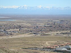
View of part of Rosamond, CA
|
|
 Location in Kern County and the state of California |
|
| Location in the United States | |
| Coordinates: 34°51′51″N 118°09′48″W / 34.86417°N 118.16333°WCoordinates: 34°51′51″N 118°09′48″W / 34.86417°N 118.16333°W | |
| Country |
|
| State |
|
| County | Kern |
| Government | |
| • Senate | Jean Fuller (R) |
| • Assembly | Tom Lackey (R) |
| • U. S. Congress | Kevin McCarthy (R) |
| Area | |
| • Total | 52.336 sq mi (135.549 km2) |
| • Land | 52.121 sq mi (134.993 km2) |
| • Water | 0.215 sq mi (0.557 km2) 0.41% |
| Elevation | 2,517 ft (767 m) |
| Population (2010) | |
| • Total | 18,150 |
| • Density | 350/sq mi (130/km2) |
| Time zone | PST (UTC-8) |
| • Summer (DST) | PDT (UTC-7) |
| ZIP code | 93560 |
| Area code(s) | 661 |
| FIPS code | 06-62826 |
| GNIS feature ID | 1661329 |
Rosamond is a census-designated place (CDP) in Kern County, California, USA, near the Los Angeles county line. 20 miles (32 km) north of Palmdale, in the Antelope Valley, the westernmost desert valley of the Mojave Desert. Rosamond is also 13 miles (21 km) south of Mojave, and 11 miles (18 km) north of Lancaster at an elevation of 2342 feet (714 m). According to 2010 United States census data, the town population was 18,150.
The Postal Service shows portions of Rosamond as having the names Tropico Village, California, named after a mine, and Willow Springs.
Rosamond Skypark Airport, Federal Aviation Administration identifier L00 (with two zeroes), is located at 34°52′15″N 118°12′32″W / 34.87083°N 118.20889°W and features a paved 3,600-foot (1,100 m) runway.
Wired telephone numbers in Rosamond follow the format (661) 256-xxxx and the entire city is included in ZIP Code 93560.
Rosamond contains the Rosamond urban area, according to the 2010 Census. The Rosamond urban area had a population of 16,000, with a land area of 6.33 square miles and a population density of 2,527 per square mile in 2010.
...
Wikipedia

