Rooster Rock State Park
| Rooster Rock State Park | |
|---|---|

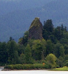
Rooster rock from the west
|
|
| Type | Public, state |
| Location | Multnomah County, Oregon |
| Nearest city | Troutdale |
| Coordinates | 45°32′40″N 122°14′09″W / 45.5445639°N 122.2359232°WCoordinates: 45°32′40″N 122°14′09″W / 45.5445639°N 122.2359232°W |
| Operated by | Oregon Parks and Recreation Department |
Rooster Rock State Park is a state park located east of Corbett, in the U.S. state of Oregon. One of the features of the park is Rooster Rock, a column of basalt forming a natural obelisk, which stands near the south side of the Columbia River Gorge, in the lee of Crown Point. The park is administered by the Oregon Parks and Recreation Department.
The monolith was noted by the explorers Lewis and Clark in their journal as their camping place on November 2, 1805. The name is phallic in origin, specifically, the column's original name was "Cock Rock". The Chinook Jargon word for the rock was iwash, referring to penis. The name was later modified to Rooster Rock so as not to offend the public.
The eastern portion of the park is designated as a clothing-optional beach, the first officially designated clothing-optional beach in the U.S. The only other clothing-optional beach in the state is Collins Beach, on Sauvie Island in the Columbia River, north of Portland.
Rooster Rock sign
Rooster Rock plaque
Squirrels at Rooster Rock State Park.
...
Wikipedia

