Roosevelt, New Jersey
| Roosevelt, New Jersey | |
|---|---|
| Borough | |
| Borough of Roosevelt | |

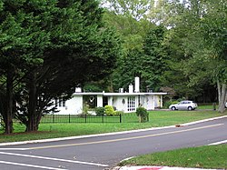
Rochdale Avenue through Roosevelt
|
|
 Map of Roosevelt in Monmouth County. Inset: Location of Monmouth County highlighted in the State of New Jersey. |
|
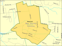
 Census Bureau map of Roosevelt, New Jersey |
|
| Coordinates: 40°13′15″N 74°28′13″W / 40.220742°N 74.470155°WCoordinates: 40°13′15″N 74°28′13″W / 40.220742°N 74.470155°W | |
| Country |
|
| State |
|
| County | Monmouth |
| Incorporated | May 29, 1937 as Jersey Homesteads |
| Renamed | November 9, 1945 as Roosevelt |
| Government | |
| • Type | Borough |
| • Body | Borough Council |
| • Mayor | Jeff Elentuck (D, term ends December 31, 2019) |
| Area | |
| • Total | 1.920 sq mi (4.972 km2) |
| • Land | 1.910 sq mi (4.947 km2) |
| • Water | 0.010 sq mi (0.026 km2) 0.52% |
| Area rank | 419th of 566 in state 32nd of 53 in county |
| Elevation | 144 ft (44 m) |
| Population (2010 Census) | |
| • Total | 882 |
| • Estimate (2016) | 854 |
| • Rank | 538th of 566 in state 49th of 53 in county |
| • Density | 461.8/sq mi (178.3/km2) |
| • Density rank | 447th of 566 in state 50th of 53 in county |
| Time zone | Eastern (EST) (UTC-5) |
| • Summer (DST) | Eastern (EDT) (UTC-4) |
| ZIP code | 08555 |
| Area code(s) | 609 |
| FIPS code | 3402564410 |
| GNIS feature ID | 0885377 |
| Website | www |
|
Jersey Homesteads Historic District
|
|
 |
|
| NRHP Reference # | 83004053 |
|---|---|
| NJRHP # | 2052 |
| Significant dates | |
| Added to NRHP | December 5, 1983 |
| Designated NJRHP | October 14, 1983 |
Roosevelt is a borough in Monmouth County, New Jersey, United States. As of the 2010 United States Census, the borough's population was 882, reflecting a decline of 51 (-5.5%) from the 933 counted in the 2000 Census, which had in turn increased by 49 (+5.5%) from the 884 counted in the 1990 Census.
The borough was established as Jersey Homesteads by an act of the New Jersey Legislature on May 29, 1937, from portions of Millstone Township. The name was changed to Roosevelt as of November 9, 1945, based on the results of a referendum held three days earlier, in honor of Franklin D. Roosevelt, who had died on April 12, 1945.
New Jersey Monthly magazine ranked Roosevelt as its 12th best place to live in its 2008 rankings of the "Best Places To Live" in New Jersey.
Roosevelt was originally called Jersey Homesteads, and was created during the Great Depression as part of President Roosevelt's New Deal, its main purpose being to resettle Jewish garment workers. The town was conceived as an integrated cooperative project, with farming, manufacturing, and retail all on a cooperative basis. The project fell under the discretion of the Resettlement Administration, but was conceived and largely planned out by Benjamin Brown.
Farmland in Central Jersey was purchased by Jersey Homesteads, Inc., a corporation owned by the federal government but under control of a board of directors selected by Brown. Construction started around 1936. Soon after there were 200 homes and various public facilities in place. The economy of the town consisted of a garment factory and a farm. Objectives of the community were to help residents escape poverty, to show that cooperative management can work, and as an experiment in government intervention.
...
Wikipedia

