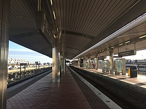
Ronald Reagan Washington National Airport Station
| Washington Metro rapid transit station | ||||||||||||||||||||||||
 |
||||||||||||||||||||||||
| Location | 2400 South Smith Boulevard Arlington, VA 22202 |
|||||||||||||||||||||||
| Coordinates | 38°51′11″N 77°02′38″W / 38.852985°N 77.0439°WCoordinates: 38°51′11″N 77°02′38″W / 38.852985°N 77.0439°W | |||||||||||||||||||||||
| Owned by | WMATA | |||||||||||||||||||||||
| Line(s) | ||||||||||||||||||||||||
| Platforms | 2 island platforms | |||||||||||||||||||||||
| Tracks | 3 | |||||||||||||||||||||||
| Connections |
|
|||||||||||||||||||||||
| Construction | ||||||||||||||||||||||||
| Structure type | Elevated | |||||||||||||||||||||||
| Bicycle facilities | 8 racks | |||||||||||||||||||||||
| Disabled access | Yes | |||||||||||||||||||||||
| Other information | ||||||||||||||||||||||||
| Station code | C10 | |||||||||||||||||||||||
| History | ||||||||||||||||||||||||
| Opened | July 1, 1977 | |||||||||||||||||||||||
| Previous names | National Airport (1977–2001) | |||||||||||||||||||||||
| Traffic | ||||||||||||||||||||||||
| Passengers (2015) | 7,284 daily |
|||||||||||||||||||||||
| Services | ||||||||||||||||||||||||
|
||||||||||||||||||||||||
Ronald Reagan Washington National Airport (formerly National Airport) is a Washington Metro station in Arlington, Virginia on the Blue and Yellow Lines. The station platform is elevated and covered and is the last above ground station on the Yellow Line in Virginia, heading into Washington, D.C. It is one of only two stations in the system to have three tracks (the other being West Falls Church). The station is located across Smith Boulevard from the B and C terminals at Ronald Reagan Washington National Airport (DCA); the airport shuttle bus carries people to and from Terminal A. The mezzanines are directly connected to the B and C terminals by pedestrian walkways to Level 2 (gate level). The airport's Abingdon Plantation historical site is near the station.
The station opened on July 1, 1977. Its opening coincided with the completion of 11.8 miles (19.0 km) of rail between National Airport and RFK Stadium and the opening of the Arlington Cemetery, Capitol South, Crystal City, Eastern Market, Farragut West, Federal Center SW, Federal Triangle, Foggy Bottom–GWU, L'Enfant Plaza, McPherson Square, Pentagon, Pentagon City, Potomac Avenue, Rosslyn, Smithsonian and Stadium–Armory stations.
...
Wikipedia
