Rome, Pennsylvania
| Rome, Pennsylvania | |
|---|---|
| Borough | |

|
|
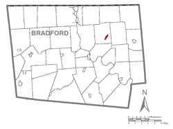
 Map of Bradford County with Rome highlighted |
|
| Location of Rome in the state of Pennsylvania | |
| Coordinates: 41°51′25″N 76°20′30″W / 41.85694°N 76.34167°WCoordinates: 41°51′25″N 76°20′30″W / 41.85694°N 76.34167°W | |
| Country | United States |
| State | Pennsylvania |
| County | Bradford |
| Settled | 1796 |
| Incorporated | 1860 |
| Area | |
| • Total | 0.53 sq mi (1.37 km2) |
| • Land | 0.52 sq mi (1.35 km2) |
| • Water | 0.008 sq mi (0.02 km2) |
| Elevation | 837 ft (255 m) |
| Population (2010) | |
| • Total | 441. |
| • Density | 848/sq mi (327.3/km2) |
| Time zone | Eastern (EST) (UTC-5) |
| • Summer (DST) | EDT (UTC-4) |
| Zip code | 18837 |
| Area code(s) | 570 Exchange: 247 |
Rome is a borough in Bradford County, Pennsylvania, United States. The population was 441 at the 2010 census.
The Phillip Paul Bliss House was added to the National Register of Historic Places in 1986.
Rome is located in northeastern Bradford County at 41°51′25″N 76°20′30″W / 41.85694°N 76.34167°W (41.856855, -76.341558), in the valley of Wysox Creek, a tributary of the Susquehanna River. It is surrounded by Rome Township but is separate from it.
Pennsylvania Route 187 passes through the borough, leading southwest 9 miles (14 km) to Towanda, the county seat, and north 12 miles (19 km) to the New York state line.
According to the United States Census Bureau, the borough has a total area of 0.54 square miles (1.4 km2), of which 0.0077 square miles (0.02 km2), or 1.42%, is water.
As of the census of 2000, there were 382 people, 157 households, and 103 families residing in the borough. The population density was 617.3 people per square mile (237.9/km²). There were 176 housing units at an average density of 284.4 per square mile (109.6/km²). The racial makeup of the borough was 98.95% White, 0.52% Native American, 0.26% Asian, and 0.26% from two or more races.
...
Wikipedia

