Rodeo–Chediski Fire
| Rodeo–Chediski Fire | |
|---|---|

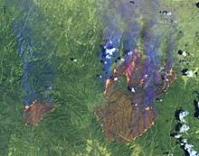
Rodeo–Chediski fires on June 28, 2002, as seen from the Landsat 7 satellite
|
|
| Location | Coconino and Navajo counties, Arizona |
| Statistics | |
| Date(s) | June 18, 2002-July 7, 2002 |
| Burned area | 468,638 acres (732.247 sq mi; 189,651 ha) |
| Cause | arson, accidental |
| Land use | forest, rural |
| Buildings destroyed |
426 |
| Perpetrator(s) | Leonard Gregg, Valinda Jo Elliott |
The Rodeo–Chediski Fire was a wildfire that burned in east-central Arizona beginning on June 18, 2002, and was not controlled until July 7. It was the worst forest fire in Arizona's recorded history until June 14, 2011 when the Wallow Fire surpassed Rodeo-Chediski as the largest fire in Arizona history. Several local communities, including Show Low, Pinetop-Lakeside, Heber-Overgaard Claysprings and Pinedale, were threatened and had to be evacuated.
Initially there were two separate fires. The first fire, the Rodeo, was reported on the afternoon of June 18 near the Rodeo Fairgrounds on the Fort Apache Indian Reservation by Cibicue. An arsonist was arrested on June 29 and was later charged. By early evening, around 1,200 acres (1.9 sq mi; 490 ha) were ablaze. Increasing wind speeds fed the fire to over 2,000 acres (3.1 sq mi; 810 ha) by the following morning, and when wind speeds increased to around 25 miles per hour (40 km/h) the fire grew rapidly, increasing fourfold over the next three hours.
The Chediski Fire was first reported on the morning of June 20 near Chediski Peak northwest of Payson. It had been started by a stranded quad runner, Valinda Jo Elliott, trying to signal a news helicopter. Similarly fed by the strong winds, this fire spread to 2,000 acres (3.1 sq mi; 810 ha) by mid-afternoon, and by the following morning it covered over 14,000 acres (22 sq mi; 5,700 ha).
By June 21 the Rodeo Fire had consumed around 150,000 acres (230 sq mi; 61,000 ha). Around 8,000 people were evacuated; by the end of the fire, around 30,000 people would be moved. The two burning areas approached through crosswinds over June 21 and June 22 as a further 11,000 people were ordered to leave their homes. The burning areas joined on June 23 having consumed around 300,000 acres (470 sq mi; 120,000 ha) of woodland. The fire's progress slowed after the two merged and by June 26 the fire was 5% contained by backburning, cutting and slurry — protecting the settlements of Clay Springs, Linden and Pinedale, but 460,000 acres (720 sq mi; 190,000 ha) had burned. The fire was 28% contained by June 28, but it was not fully under control until July 7 at a cost of $43.1 million. About 400 homes were destroyed in Pinedale and other small communities. The fire was declared a disaster area. RodeoFire.com was established at the fire's onset as a portal for concerned citizens and family members acting as an event update website.
...
Wikipedia
