Rockwood, Pennsylvania
|
Rockwood, Pennsylvania previously Mineral Point (c. 1857) |
|
|---|---|
| Borough | |

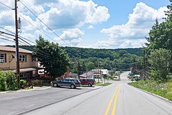
View down Bridge St.
|
|
| Coordinates: 39°54′58″N 79°09′21″W / 39.91611°N 79.15583°WCoordinates: 39°54′58″N 79°09′21″W / 39.91611°N 79.15583°W | |
| Country | United States |
| State | Pennsylvania |
| County | Somerset |
| Settled | 1857 |
| Incorporated | 1885 |
| Government | |
| • Type | Borough Council |
| Area | |
| • Total | 0.3 sq mi (0.8 km2) |
| Elevation | 1,837 ft (560 m) |
| Population (2000) | |
| • Total | 954 |
| • Density | 3,053.4/sq mi (1,178.9/km2) |
| Time zone | Eastern (EST) (UTC-5) |
| • Summer (DST) | EDT (UTC-4) |
| Zip code | 15557 |
| Area code(s) | 814 |
Rockwood is a borough in Somerset County, Pennsylvania, United States. The population was 954 at the 2000 census. It is part of the Johnstown, Pennsylvania Metropolitan Statistical Area, and located due North of Pennsylvania's highest peak, Mount Davis, which significantly constricts land travel routing south of the municipality.
The Penrose Wolf Building was added to the National Register of Historic Places in 2002. The town sits astride the historic Baltimore and Ohio railway right of way as it bent northerly in a long bow about the roots of Mount Davis, now owned and operated by CSX, with daily Amtrak express trains between Pittsburgh and Cumberland, MD passing through the town and the nearby Cumberland Narrows. It is situated near and below the West slope-side summit-point of both the Nemacolin Trail and Braddock's Road, as well as the railway as each ascended past the crest up through the Cumberland Narrows pass from the forks of the Potomac at Harper's Ferry. The town was thus an important stop over point in the post-American Revolution westward migration into the Ohio Country and via the river boats built in Brownsville.
Rockwood is located at 39°54′58″N 79°9′21″W / 39.91611°N 79.15583°W (39.916222, -79.155808). It is situated near and below the West-side crest of the Eastern Continental Divide separating the Potomac-Mississippi riverine systems along the north bank of the Casselman River—whose head waters are to the south in nearby Western Maryland—and just west of its confluence with Coxes Creek.
...
Wikipedia

