Rockville, UT
| Rockville, Utah | |
|---|---|
| Town | |
 |
|
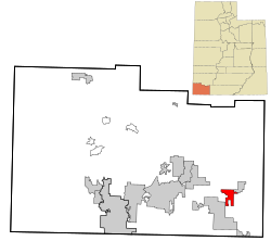
 Location in Washington County and the state of Utah |
|
| Coordinates: 37°9′41″N 113°2′15″W / 37.16139°N 113.03750°WCoordinates: 37°9′41″N 113°2′15″W / 37.16139°N 113.03750°W | |
| Country | United States |
| State | Utah |
| County | Washington |
| Settled | 1860 |
| Incorporated | June 30, 1987 |
| Area | |
| • Total | 8.4 sq mi (21.8 km2) |
| • Land | 8.4 sq mi (21.8 km2) |
| • Water | 0.0 sq mi (0.0 km2) |
| Elevation | 3,740 ft (1,140 m) |
| Population (2012) | |
| • Total | 251 |
| • Density | 29.3/sq mi (11.3/km2) |
| Time zone | Mountain (MST) (UTC-7) |
| • Summer (DST) | MDT (UTC-6) |
| ZIP code | 84763 |
| Area code(s) | 435 |
| FIPS code | 49-64560 |
| GNIS feature ID | 1431946 |
Rockville is a town in Washington County, Utah, United States. It is located along the Virgin River near the mouth of Zion Canyon. The city lies just outside the park boundary for Zion National Park; the park entrance is located approximately 5 miles (8 km) northeast of the town.
According to the United States Census Bureau, the town has a total area of 8.4 square miles (21.8 km²), all of it land.
This region experiences warm (but not hot) and dry summers, with no average monthly temperatures above 71.6 °F. According to the Köppen Climate Classification system, Rockville has a warm-summer Mediterranean climate, abbreviated "Csb" on climate maps.
As of the census of 2010, there were 245 people, 119 households, and 63 families residing in the town. The population density was 29.3 people per square mile (11.3/km²). There were 142 housing units at an average density of 16.9 per square mile (6.5/km²). The racial makeup of the town was 96.76% White, 0.40% Asian, 1.21% from other races, and 1.62% from two or more races. Hispanic or Latino of any race were 6.88% of the population.
...
Wikipedia

