Rockport, Arkansas
| Rockport, Arkansas | |
|---|---|
| City | |
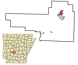
 Location in Hot Spring County and the state of Arkansas |
|
| Location of Sherrill in the US | |
| Coordinates: 34°24′9″N 92°48′40″W / 34.40250°N 92.81111°WCoordinates: 34°24′9″N 92°48′40″W / 34.40250°N 92.81111°W | |
| Country |
|
| State |
|
| County | Hot Spring |
| Townships | Butterfield, Fenter |
| Founded | 1846 |
| Incorporated | 1851 |
| Government | |
| • Type | Mayor–Council |
| • Mayor | Darrell Hughes (I) |
| • Council | |
| Area | |
| • Total | 3.4 sq mi (8.8 km2) |
| • Land | 3.4 sq mi (8.8 km2) |
| • Water | 0 sq mi (0 km2) |
| Elevation | 331 ft (101 m) |
| Population (2010) | |
| • Total | 755 |
| • Density | 222/sq mi (85.6/km2) |
| Time zone | CST (UTC−06:00) |
| • Summer (DST) | CDT (UTC−05:00) |
| ZIP code | 72104 |
| Area code | 501 |
| FIPS code | 05-60020 |
| GNIS feature ID | 0058508 |
| Major airport | LIT |
Rockport is a city on the Ouachita River in Hot Spring County, Arkansas, United States. As of the 2010 census, the population of Rockport was 755, down from 792 in 2000.
Rockport is one of the oldest named places in Arkansas. Although the present city is overshadowed by Malvern, Rockport served as the county seat of Hot Spring County from 1846 to 1879 and was a landmark community of Arkansas for many years both before and after that time.
Large novaculite boulders in the bed of the Ouachita River made the location of Rockport ideal as both a river crossing and a resting place for weary river travelers. These boulders gave the community its name. A plaque in Rockport states that Spanish explorer Hernando de Soto visited the location in 1541, although current historians are less certain about the exact route that de Soto and his group traveled while west of the Mississippi River. French hunters and trappers definitely forded the river at this location. The Hunter-Dunbar Expedition struggled to navigate the rapids here on December 3, 1804, recording their experience in a travel diary. During the 1830s, the development of the Military Road (also called the Southwest Trail) used the boulders as a ford to cross the river. Around 1847, a bridge was completed across the Ouachita River at Rockport, which is said to be the first toll bridge built in Arkansas. Over the years, it repeatedly washed away and was rebuilt.
By that time, the settlement was already populated. Its most famous citizen was politician Lorenzo Gibson, who built a house on a bluff overlooking the river and who became, in 1837, Rockport’s first postmaster. Other early settlers were Colonel A. R. Givens, Henry Miller, and Samuel Emerson, who is credited with laying out the city and opening its first hotel. Three doctors and a lawyer also made their homes in Rockport while Arkansas was still a territory. Hot Spring County was formed in 1829, with its county seat at Hot Springs (Garland County), but the seat of county government was moved to Rockport in 1846. At that time, the city already had a gristmill, a shop where wagons were built, stores, and residences. A Methodist church was meeting in a private home as early as 1815; its first building, a log structure, was erected in 1836. Rockport Baptist Church began holding services in 1849 and also housed Rockport’s first school. New Hope Baptist Church was established in 1859.
...
Wikipedia

