Rocklin, California
| Rocklin, California | |
|---|---|
| City | |
| City of Rocklin | |

Amtrak station and Chamber of Commerce, Rocklin
|
|
| Motto: "A Family Community" | |
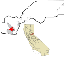
 Location in Placer County and the state of California |
|
| Location in the United States | |
| Coordinates: 38°48′0″N 121°14′48″W / 38.80000°N 121.24667°WCoordinates: 38°48′0″N 121°14′48″W / 38.80000°N 121.24667°W | |
| Country |
|
| State |
|
| County | Placer |
| Incorporated | February 24, 1893 |
| Government | |
| • State Senate | Ted Gaines (R) |
| • State Assembly | Beth Gaines (R) |
| • U. S. Congress | (R) |
| Area | |
| • Total | 19.594 sq mi (50.749 km2) |
| • Land | 19.541 sq mi (50.610 km2) |
| • Water | 0.053 sq mi (0.139 km2) 0.27% |
| Elevation | 249 ft (79 m) |
| Population (2014) | |
| • Total | 60,344 |
| • Density | 3,100/sq mi (1,200/km2) |
| Demonym(s) | Rocklinite |
| Time zone | PST (UTC-8) |
| • Summer (DST) | PDT (UTC-7) |
| ZIP codes | 95677, 95765 |
| Area code(s) | 916 |
| FIPS code | 06-62364 |
| GNIS feature ID | 0277586 |
| Website | www |
Rocklin is a city in Placer County, California located approximately 22 miles (35 km) from Sacramento, California, and about 6.1 miles (9.8 km) northeast of Roseville in the Sacramento metropolitan area. Besides Roseville, it shares borders with Granite Bay, Loomis and Lincoln. As of the 2010 census, Rocklin's population was 56,974.
Prior to the California Gold Rush the Nisenan Maidu occupied both permanent villages and temporary summer shelters along the rivers and streams which miners sifted, sluiced, dredged and dammed to remove the gold. Explorer Jedediah Smith and a large party of American fur trappers crossed the Sacramento Valley in late April, 1827. The group saw many Maidu villages along the river banks. Deprived of traditional foodstuffs, homesites and hunting grounds by the emigrants, the Nisenan were among the earliest California Indian tribes to disappear.
During the 1850s, miners sluiced streams and rivers including Secret Ravine which runs through Rocklin. The piles of dredger tailings is still obvious today, between Roseville and Loomis southeast of Interstate 80. Secret Ravine at the area now at the intersection of Ruhkala Road and Pacific Street was later mined for granite, some of which was used as the base course of the California Capitol Building in Sacramento, although the earliest recorded use of the rock was for Fort Mason at San Francisco in 1855. The granite was hauled out by ox carts before the arrival of the railroad many years later.
In 1860, the U.S. Census counted 440 residents in the area of Secret Ravine, of which approximately 16% had been born in Ireland and the majority of whom worked as miners. The area was referred to as Secret Ravine or the "granite quarries at the end of the tracks" as late as 1864.
...
Wikipedia

