Rock Island State Park (Tennessee)
| Rock Island State Park | |
|---|---|

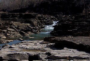
The Caney Fork in the Great Falls Gorge
|
|
| Location | Rock Island, Warren County and White County, Tennessee, United States |
| Coordinates | 35°48′31″N 85°38′29″W / 35.80851°N 85.64150°WCoordinates: 35°48′31″N 85°38′29″W / 35.80851°N 85.64150°W |
| Area | 883 acres (3.57 km2) |
| Created | 1969 |
| Open | Year around |
| Website | official website |
Rock Island State Park is a state park in Warren County and White County, Tennessee, located in the Southeastern United States. The park is named after the community of Rock Island, Tennessee, which in turn received its name from an island on the Caney Fork upstream from the Collins River confluence and Great Falls Dam. Rock Island State Park is centered on a peninsula created by the confluence of these two rivers and extends downstream to the headwaters of Center Hill Lake.
The park consists of 883 acres (3.57 km2) and is managed by the Tennessee Department of Environment and Conservation.
The Caney Fork winds its way westward from its source atop the Cumberland Plateau and drops down to the Highland Rim at Scott's Gulf, where it enters White County. Just past Scott's Gulf, the river gains strength, absorbing Cane Creek and the Calfkiller River as it winds along the base of the plateau. At the community of Walling, the river briefly turns southward and absorbs the Rocky River before turning westward again. Two miles beyond its Rocky River confluence, the Caney Fork absorbs the Collins and enters the Great Falls Gorge. Beyond the gorge, the river enters the upper extremes of its Center Hill Lake impoundment and begins winding its way northward toward its mouth along the Cumberland River, near Carthage.
The Collins River rises atop the Cumberland Plateau several miles south of Rock Island State Park at the head of a canyon known as Savage Gulf. The river winds its way northward through a section of the Highland Rim known as "the Barrens," and steadies as it enters the eastern section of McMinnville. The river almost joins the Caney Fork at a point just opposite the Great Falls Dam power plant, but instead bends southward to create the peninsula where the present park is located.
...
Wikipedia
