Rocky River (Tennessee)
| Rocky River | |
| River | |
|
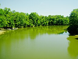
View from the Bone Cave Road bridge
|
|
| Country | United States |
|---|---|
| State | Tennessee |
| Source | Jakes Mountain in Sequatchie County |
| - elevation | 1,880 ft (573 m) |
| - coordinates | 35°31′57″N 85°29′10″W / 35.53250°N 85.48611°W |
| Mouth | Great Falls Lake (Caney Fork) at Rock Island |
| - elevation | 804 ft (245 m) |
| - coordinates | 35°47′37″N 85°36′9″W / 35.79361°N 85.60250°WCoordinates: 35°47′37″N 85°36′9″W / 35.79361°N 85.60250°W |
| Length | 31 mi (50 km) |
| Basin | 111 sq mi (287 km2) |
The Rocky River is a 31.0-mile-long (49.9 km) stream in the east-central portion of Middle Tennessee in the United States. It is a tributary of the Caney Fork River, and is part of the Cumberland, Ohio and Mississippi watersheds. The lower portion of the river is part of the reservoir created by Great Falls Dam, which is located near the river's confluence with the Caney Fork.
The Rocky River rises on the slopes of Jakes Mountain, a 2,204-foot (672 m) summit north of the Cagle community atop the Cumberland Plateau in Sequatchie County. Just below its source, the stream enters its Studer Lake impoundment as it flows northward through a rugged area of abandoned surface mines. Beyond this lake, the river crosses into Van Buren County, where it continues northward through rugged hills.
After passing the historic "Rocky River Crossing" (once part of the Trail of Tears) along Pleasant Hill Cemetery Road, the river begins its descent to the Highland Rim, losing 900 feet in elevation in less than four miles before steadying in the White Hill area. Flanked by the walls of the Cumberland Plateau and Barnett Mountain, the river continues northward through the Riverview and Laurelburg communities. At the latter, the river veers westward toward Warren County, then again turns northward, forming the boundary between Warren and Van Buren for the remainder of its course.
Just before reaching the Goodbars community, the river passes under State Highway 30 (Spencer Road). Beyond Goodbars, the river flows through a series of oxbow bends, one of which nearly forms a meander cutoff. After passing under Bone Cave Road and U.S. Highway 70, the river flows just east of the Rock Island community as it enters the slack waters of Great Falls Lake. The river empties into the Caney Fork about a mile upstream from Great Falls Dam. Its confluence with the Caney Fork marks a three-way junction between Warren, Van Buren, and White counties.
...
Wikipedia

