Riverside, Missouri
| Riverside, Missouri | |
|---|---|
| City | |
 Location of Riverside, Missouri |
|
 |
|
| Coordinates: 39°10′30″N 94°37′21″W / 39.17500°N 94.62250°WCoordinates: 39°10′30″N 94°37′21″W / 39.17500°N 94.62250°W | |
| Country | United States |
| State | Missouri |
| County | Platte |
| Area | |
| • Total | 5.79 sq mi (15.00 km2) |
| • Land | 5.51 sq mi (14.27 km2) |
| • Water | 0.28 sq mi (0.73 km2) |
| Elevation | 774 ft (236 m) |
| Population (2010) | |
| • Total | 2,937 |
| • Estimate (2012) | 3,011 |
| • Density | 533.0/sq mi (205.8/km2) |
| Time zone | Central (CST) (UTC-6) |
| • Summer (DST) | CDT (UTC-5) |
| ZIP codes | 64150, 64151, 64168 |
| Area code(s) | 816 |
| FIPS code | 29-62156 |
| GNIS feature ID | 0725347 |
Riverside is a city in Platte County, Missouri, United States. The population was 2,937 at the 2010 census.
The town on the edge of the Missouri River and was formally incorporated in 1951.
For many years the town was known for its Riverside Race Track. The Riverside Park Jockey Club operated from 1928 to 1937 and was popularly called “Pendergast Track” after its patron Big City Boss Tom Pendergast (although Pendergast was not officially on its organization papers). The horse racing track was on the site of a former dog racing track. The track operated under a questionable legal basis. The site was supplanted by an automobile race track which closed in the 1990s.
A legal gambling establishment on the river now is the $106 million casino run by Argosy Gaming Company.
One of the landmarks in Riverside is the Riverside Red X store. It was founded in the 1950s by Edward Young and his family. The store is famous for selling cheap beer, wine, cigarettes and gasoline. They are also famous for rebuilding after many floods and fires.
Park Hill South High School, the second established high school in the Park Hill School District, is located in Riverside.
On August 22, 2007, President George W. Bush met with residents at the Corner Cafe in Riverside to discuss local issues.
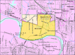
Riverside is located at 39°10′30″N 94°37′21″W / 39.17500°N 94.62250°W (39.174903, -94.622414).
...
Wikipedia
