River Torrens
| Torrens | |
| River | |
|
View of Elder Park, the Riverside Precinct and the Torrens Lake, before construction of the pedestrian bridge in 2014.
|
|
| Country | Australia |
|---|---|
| State | South Australia |
| Region | Adelaide Plains |
| Source | Mount Lofty Ranges |
| - location | Mount Pleasant |
| - elevation | 480 m (1,575 ft) |
| Mouth | Gulf St Vincent |
| - location | Henley Beach South |
| - elevation | 0 m (0 ft) |
| - coordinates | 34°55′S 138°36′E / 34.917°S 138.600°ECoordinates: 34°55′S 138°36′E / 34.917°S 138.600°E |
| Length | 85 km (53 mi) |
| Basin | 508 km2 (196 sq mi) |
| Discharge | for mouth |
| - average | 0.71 m3/s (25 cu ft/s) |
| Reservoir | Kangaroo Creek Reservoir |
|
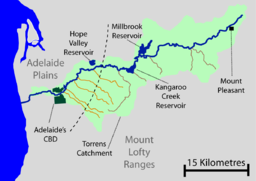
Torrens catchment, creeks and reservoirs
|
|
|
Location of the river mouth in South Australia
|
|
The River Torrens /ˈtɒrənz/ is the most significant river of the Adelaide Plains and was one of the reasons for the siting of the city of Adelaide, capital of South Australia. It flows 85 kilometres (53 mi) from its source in the Adelaide Hills near Mount Pleasant, across the Adelaide Plains, past the city centre and empties into Gulf St Vincent between Henley Beach South and West Beach. The upper stretches of the river and the reservoirs in its watershed supply a significant part of the city's water supply. The river's long linear parks and a constructed lake in the lower stretch are iconic of the city.
At its 1836 discovery an inland bend was chosen as the site of the Adelaide city centre and North Adelaide. The river is named after Colonel Robert Torrens, chairman of the colonial commissioners and a significant figure in the city's founding. The river is also known by its native Kaurna name Karra wirra-parri. The river and its tributaries are highly variable in flow, and together drain an area of 508 square kilometres (196 sq mi). They range from sometimes raging torrents, damaging bridges and flooding city areas, to trickles and completely dry in summer. Winter and spring flooding has prompted the construction of flood reduction works. A constructed sea outlet, landscaped linear parks and three holding reservoirs contain peak flow.
...
Wikipedia


