River Ticino
| Ticino | |
|---|---|

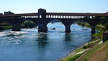
The river Ticino and the Covered Bridge of Pavia
(originally medieval in date, rebuilt in 1950 after the destruction due to war bombing) |
|
 |
|
| Country | Switzerland, Italy |
| Basin features | |
| Main source | Val Bedretto, Ticino, Switzerland about 2,478 m (8,100 ft) |
| River mouth | River Po, south-east of Pavia, Italy |
| Basin size | 7,228 km2 (2,791 sq mi) |
| Physical characteristics | |
| Length | 248 km (154 mi) |
| Discharge |
|
The river Ticino (/tᵻˈtʃiːnoʊ/; Italian pronunciation: [tiˈtʃiːno]; Lombard: Tisín; French and German: Tessin; Latin: Ticīnus) is the most important perennial left-bank tributary of the Po River. It has given its name to the Swiss canton through which its upper portion flows.
The river rises in the Val Bedretto in Switzerland at the frontier between the cantons of Valais and Ticino, is fed by the glaciers of the Alps and later flows through Lake Maggiore, before entering Italy. The Ticino joins the Po a few kilometres downstream (along the Ticino) from Pavia. It is about 248 kilometres (154 mi) long. The highest point of the drainage basin is the summit of Grenzgipfel (a subpeak of Monte Rosa), at 4,618 metres (15,151 ft). Beneath it flows the Anza River, a right-bank tributary of the Ticino.
The river is dammed in Switzerland in order to create hydroelectricity, while in Italy it is primarily used for irrigation.
...
Wikipedia
