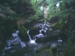
River Spodden
| River Spodden | |
| River | |
|
Fairies Chapel, Healey Dell
|
|
| Country | England |
|---|---|
| Source | |
| - location | Freeholds Top, Shawforth, Whitworth, Lancashire |
| Mouth | |
| - location | River Roch, Rochdale |
| - coordinates | 53°36′55.43″N 2°9′59.85″W / 53.6153972°N 2.1666250°WCoordinates: 53°36′55.43″N 2°9′59.85″W / 53.6153972°N 2.1666250°W |
The River Spodden is a watercourse in North West England, one of two major tributaries of the River Roch. It rises in the Lancashire South Pennine hills north of Whitworth and flows south through what is now known as the Whitworth Valley to Rochdale, Greater Manchester, where the river merges with the River Roch. Nestled within the picturesque wooded valley is Healey Dell Nature Reserve.
The river rises at Freeholds Top, on Shawforth Moor, north-east of Shawforth village, Whitworth, east of Britannia, out of Bacup, and south-west of Inchfield Moor. In the early 19th Century, the source was listed as "near High House". It flows south through its narrow valley through Shawforth, Facit, Whitworth and Broadley, and for about a kilometre it forms the boundary between both Rochdale and Rossendale districts and Greater Manchester and Lancashire counties. It then flows through Healey Dell, Shawclough, Lowerfold, Spotland Fold and Spotland Bridge to join the Roch at Mitchell Hey, Rochdale, some four kilometres downstream from the Roch's other major tributary, the River Beal. The River Spodden falls 235 metres in its length of 12 kilometres, and is fed by nine direct tributary streams and a further four indirect streams.
The River Spodden has been known by many variant names over the centuries. It was known by the name of "Sprotton" in 1577, as the "Spotton brook" in 1611, It gave its name to the township of Spotland, one of the four original townships in the Parish of Rochdale, which was first known as "Spoddenland", and, within that township, acted as the boundary between its subsequent divisions of Spotland Further-Side (to the west) and Spotland Nearer-Side (to the east). Spotland was known by that name in 1066, recorded "as part of the possession of Gamel the Thane, immediately after the Conquest", and the river's name predates that. The river was also known in the 18th and 19th Centuries as the Spod or Spot; "In ancient charters this rivulet is spelt Spod, and Spodden sometimes occurs." Dr. Whitaker, a respected local historian, writing in the early 1800s, stated that "Spod or Spud, in some dialects of the Teutonic language, signifies a spear, and the term appears to have been applied to this stream, from the unbended straightness of its course, which terminates at its junction with the Roch. " The Spodden valley, and Spotland, was described in 1854 as "a district where the leaven of the old Saxon tongue, customs and character is less adulterated than in most other parts of Lancashire, as the naming of the Thrutch, below, indicates. The road alongside the river, northwards from Spotland Bridge, was, and remains, Spod Lane. The river was known locally as the Spod as late as the end of the 1970s.
...
Wikipedia

