River Nahe
| Nahe | |
|---|---|

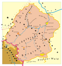
Drainage basin of the Nahe river and its tributaries
|
|
| Country | Germany |
| Basin features | |
| Main source | Hunsrück |
| River mouth |
Rhine 49°58′11″N 7°53′21″E / 49.96972°N 7.88917°ECoordinates: 49°58′11″N 7°53′21″E / 49.96972°N 7.88917°E |
| Basin size | 4,067 km2 (1,570 sq mi) |
| Physical characteristics | |
| Length | 125.1 km (77.7 mi) |
The Nahe is a river in Rhineland-Palatinate and Saarland, Germany, a left tributary to the Rhine. It has also given name to the wine region Nahe situated around it.
The name Nahe is derived from the Latin word Nava, which is supposed to be based upon the Celtic origin for the wild river. The Nahe separates the northern part of the Palatinate from the Hunsrück.
It rises in the area of Nohfelden (Saarland), flowing through Rhineland-Palatinate and joining the Rhine in Bingen. Its length is 125 kilometres (78 mi). Towns along the Nahe include Idar-Oberstein, Kirn, Bad Kreuznach and Bingen.
The drainage basin of the river covers an area of 4,067 square kilometres (1,570 sq mi). Due to this relatively large area compared to the river's length high floods can occur along its middle and lower course within only a few hours, however flowing off also quickly. In 1993 and 1995 in Bad Kreuznach a flow of more than 1,000 cubic metres per second (35,000 cu ft/s) was measured and more than 1,300 cubic metres per second (46,000 cu ft/s) at its mouth into the Rhine.
The dimensions of the drainage basin are shown in the map. Its boundaries clock-wise, beginning in the East:
The rocks in the Nahe region are predominantly of Cisuralian (early Permian) age and part of the Rotliegendes. At that time, an impetuous volcanism appeared in the region. Huge deposits of the reddish volcanic rock Rhyolite and of the more alkaline volcanic rock Andesite were left. The valleys of the Nahe and its tributaries have been being formed since 2.6 million years ago during the Quaternary, the geologically latest period, as a result of ground heaving of the surrounding mountains of Hunsrück and North Palatine Uplands. This led to a steep decline of all waters and hence to strong erosion activities. Particularly strong erosion occurred in warmer melting periods during the ice ages, when tundra climate reigned and the soil was not protected by a dense cover of vegetation. Depending on the underground, narrow gorges with cliffy precipices arose in areas with hard volcanic rocks or wide gentle valleys with flood plains in areas with soft sedimentary deposits. The frequent change between both forms is charming along the Nahe.
...
Wikipedia
