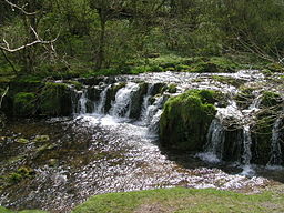
River Lathkill
| Lathkill | |
| River | |
|
Tufa dam, River Lathkill
|
|
| Country | England |
|---|---|
| Counties | Derbyshire |
| Tributaries | |
| - right | River Bradford, Ivy Bar Brook |
| Source | |
| - location | Lathkill Head nr Monyash |
| - coordinates | 53°11′22″N 1°44′47″W / 53.1895°N 1.7463°W |
| Mouth | |
| - location | River Wye nr Rowsley |
| - coordinates | 53°11′19″N 1°38′21″W / 53.1887°N 1.6392°WCoordinates: 53°11′19″N 1°38′21″W / 53.1887°N 1.6392°W |
| Length | 10.5 km (7 mi) |
| Progression : Lathkill—Wye—Derwent—Trent—Humber—North Sea | |
The River Lathkill is a river in the Peak District National Park in Derbyshire, England.
First recorded in 1280, the name "Lathkill" possibly has Scandinavian roots, the old Norse hlada-kill translating as "narrow valley with a barn".
In times of high rainfall the source of the river is Lathkill Head Cave (SK170658), but in normal conditions the river rises from springs slightly further down the valley, close to the village of Monyash, west of Bakewell, and flows generally eastward past the village of Over Haddon and through the village of Alport (where it is joined by the River Bradford) until it meets the River Wye near Rowsley. Roughly six and a half miles from source to outfall, it is the only river in the district that flows over limestone for its entire length.
The river valley, known as Lathkill Dale, is popular with tourists who visit for its natural environment and wildlife. The medieval Conksbury Bridge (SK211656) now carries the road from Bakewell to Youlgreave. The dale has a history of lead mining, and among the trees on the north side of the valley are the remains of the 19th-century Mandale Mine, including an old aqueduct and the ruined pump house, used as one of the last attempts to keep the mines drained and workable.
...
Wikipedia

