River Bulbourne
| Bulbourne | |
| River | |
|
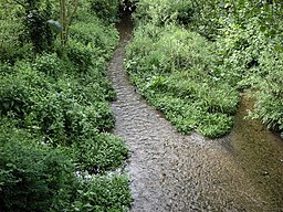
River Bulbourne in Berkhamsted (reduced by the Grand Union canal a couple of metres away)
|
|
| Country | United Kingdom |
|---|---|
| Source | |
| - location | Cow Roast/ Dudswell, Northchurch |
| - elevation | 120 m (394 ft) |
| - coordinates | 51°46′41″N 0°36′04″W / 51.778°N 0.601°W |
| Mouth | |
| - location | Two Waters Apsley, Hemel Hempstead |
| - elevation | 90 m (295 ft) |
| - coordinates | 51°44′20″N 0°28′16″W / 51.739°N 0.471°WCoordinates: 51°44′20″N 0°28′16″W / 51.739°N 0.471°W |
| Length | 11 km (7 mi) |
The River Bulbourne is a small river in Dacorum, Hertfordshire, England. The word bourne derives from the Anglo-Saxon word for a stream. It is an unnavigable tributary of the River Gade, which flows into the River Colne, which in turn is a tributary of the River Thames.
The Bulbourne is one of only 210 chalk streams in the world. It flows in the Chiltern Hills, part of a system of chalk downlands throughout eastern and southern England, which formed between 84 and 100 million years ago in the Cretaceous Period when the area was a chalk-depositing marine environment. The valley is at the southernmost limit of the Pleistocene glaciation ice erosion of the Chiltern scarp, giving it a smooth rounded appearance. The underlying geology is chalk, which outcrops in places along the east side of the valley. The subsoil is predominantly a stiff reddish clay-with-flints; in the valley itself the chalk is overlain with alluvium. Around Berkhamsted the valley sides rise 300 ft. Situated on its northern rim, the valley is a small part of a larger syncline or down folding of rocks called the London Basin.
The river runs in a south-easterly direction from between the Cow Roast and Dudswell in Northchurch, through Berkhamsted, Bourne End and Boxmoor to where it joins the River Gade at Two Waters in Apsley near Hemel Hempstead. The current total length of the river is 7 miles (11 km), from its source to its mouth it falls 30 meters (98 ft).
...
Wikipedia

