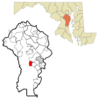
Riva, Maryland
| Riva, Maryland | |
|---|---|
| Census-designated place | |
 Location of Riva, Maryland |
|
| Coordinates: 38°57′7″N 76°34′56″W / 38.95194°N 76.58222°WCoordinates: 38°57′7″N 76°34′56″W / 38.95194°N 76.58222°W | |
| Country | |
| State |
|
| County |
|
| Area | |
| • Total | 2.9 sq mi (7.5 km2) |
| • Land | 2.5 sq mi (6.4 km2) |
| • Water | 0.5 sq mi (1.2 km2) |
| Elevation | 43 ft (13 m) |
| Population (2010) | |
| • Total | 4,076 |
| • Density | 1,659/sq mi (640.7/km2) |
| Time zone | Eastern (EST) (UTC-5) |
| • Summer (DST) | EDT (UTC-4) |
| ZIP code | 21140 |
| Area code(s) | 410 |
| FIPS code | 24-66400 |
| GNIS feature ID | 0591136 |
Riva is a census-designated place (CDP) in Anne Arundel County, Maryland, United States. The population was 4,076 at the 2010 census. The area is scenic, especially where the two-lane Riva Road crosses the South River on a bridge. The area is growing with large new homes as the suburbs of Annapolis grow outward.
Aisquith Farm E Archeological Site was listed on the National Register of Historic Places in 1991.
Riva is located at 38°57′7″N 76°34′56″W / 38.95194°N 76.58222°W (38.952079, -76.582135).
According to the United States Census Bureau, the CDP has a total area of 2.9 square miles (7.5 km2), of which 2.5 square miles (6.4 km2) is land and 0.46 square miles (1.2 km2), or 15.37%, is water.
As of the census of 2000, there were 3,966 people, 1,423 households, and 1,169 families residing in the CDP. The population density was 1,589.0 people per square mile (612.5/km²). There were 1,453 housing units at an average density of 582.2/sq mi (224.4/km²). The racial makeup of the CDP was 94.23% White, 3.43% African American, 1.21% Asian, 0.15% from other races, and 0.98% from two or more races. Hispanic or Latino of any race were 2.12% of the population.
...
Wikipedia
