Rison, Arkansas
| Rison, Arkansas | |
|---|---|
| City | |

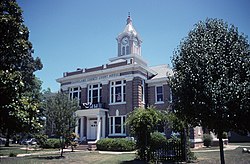
Cleveland County Courthouse in Rison - listed on National Register of Historic Places
|
|
 Location in Cleveland County and the state of Arkansas |
|
| Coordinates: 33°57′26″N 92°11′23″W / 33.95722°N 92.18972°WCoordinates: 33°57′26″N 92°11′23″W / 33.95722°N 92.18972°W | |
| Country | United States |
| State | Arkansas |
| County | Cleveland |
| Government | |
| • Mayor of Rison | Vernon R. Dollar |
| Area | |
| • Total | 2.6 sq mi (6.8 km2) |
| • Land | 2.6 sq mi (6.8 km2) |
| • Water | 0 sq mi (0 km2) |
| Elevation | 269 ft (82 m) |
| Population (2010) | |
| • Total | 1,344 |
| • Density | 513/sq mi (197.9/km2) |
| Time zone | Central (CST) (UTC-6) |
| • Summer (DST) | CDT (UTC-5) |
| ZIP code | 71665 |
| Area code(s) | 870 |
| FIPS code | 05-59480 |
| GNIS feature ID | 0058495 |
Rison is a city in and the county seat of Cleveland County,Arkansas, United States. Its population was 1,344 at the 2010 U.S. census. It is included in the Pine Bluff, Arkansas Metropolitan Statistical Area.
Rison had its start in 1883, shortly after the railroad was built through that territory. It was named for William Richard Rison, an Alabama banker and friend of the founder of the town.
Rison is located in north-central Cleveland County at 33°57′26″N 92°11′23″W / 33.957089°N 92.189711°W.U.S. Route 79 passes through the western side of the city, leading northeast 25 miles (40 km) to Pine Bluff and southwest 17 miles (27 km) to Fordyce.
According to the United States Census Bureau, the city has a total area of 2.6 square miles (6.8 km2), all of it land.
As of the census of 2000, there were 1,271 people, 471 households, and 324 families residing in the city. The population density was 475.1 people per square mile (183.8/km²). There were 532 housing units at an average density of 198.9/sq mi (76.9/km²). The racial makeup of the city was 62.23% White, 33.36% Black or African American, 0.31% Native American, 0.24% Asian, 1.73% from other races, and 2.12% from two or more races. 2.20% of the population were Hispanic or Latino of any race.
...
Wikipedia
