Rio Hato Army Air Base
| Scarlett Martínez International Airport | |||||||||||
|---|---|---|---|---|---|---|---|---|---|---|---|

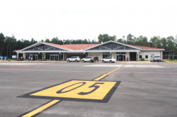
Terminal building seen from the runway
|
|||||||||||

Sunwing Airlines inaugural flight, 2015
|
|||||||||||
| Summary | |||||||||||
| Airport type | Public | ||||||||||
| Serves | Rio Hato, Coclé, Panama | ||||||||||
| Location | Coclé, Panama | ||||||||||
| Elevation AMSL | 32 m / 105 ft | ||||||||||
| Coordinates | 08°22′33″N 080°07′40″W / 8.37583°N 80.12778°WCoordinates: 08°22′33″N 080°07′40″W / 8.37583°N 80.12778°W | ||||||||||
| Map | |||||||||||
| Location in Rio Hato, Coclé, Panamá | |||||||||||
| Runways | |||||||||||
|
|||||||||||
|
Source: GCM,
|
|||||||||||
Scarlett Martínez International Airport (IATA: RIH, ICAO: MPSM), also known as Río Hato Airport, is a small international airport located in Río Hato, Coclé, Panama.
Established in 1931, during World War II Río Hato Army Air Base was used by the United States Army Air Forces Sixth Air Force as part of the defense of the Panama Canal. It was closed as an active Air Force facility in 1948 but was used as an USAF auxiliary military landing field as late as 1990 as part of Howard Air Force Base.
Units assigned to the base were:
| style="width: 50%;text-align: left; vertical-align: top; " |
During Operation Just Cause, The United States Army 2d and 3d Battalions, 75th Ranger Regiment (TF RED ROMEO), departed Lawson Army Airfield, Fort Benning, Georgia, at 18:00 on 19 December 1989. Its mission was to seize Río Hato and neutralize the 6th and 7th PDF Infantry Cos. At 01:00 on 20 December, the battalion jumped from C-130s onto the airfield at Río Hato. Both PDF companies had been alerted and fired on the C-130s with small arms and anti-aircraft guns. Despite PDF resistance, the battalion assembled, attacked the barracks, and established an airhead. By morning, the Rangers had accomplished all missions, captured 250 prisoners, and cleared the airfield for future operations.
...
Wikipedia

