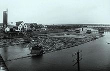
Rimouski River
| Rimouski River | |
|---|---|

Price sawmill on Rimouski River in 1914
|
|
| Country | Canada |
| City | Rimouski |
| Basin features | |
| Main source |
Saint-Quentin Parish, New Brunswick, Restigouche County, 460 m (1,510 ft) 47°53′37″N 68°20′08″W / 47.89361°N 68.33556°W |
| River mouth |
Rimouski, MRC of Rimouski-Neigette, 0 m (0 ft) 48°28′14″N 68°31′17″W / 48.47056°N 68.52139°WCoordinates: 48°28′14″N 68°31′17″W / 48.47056°N 68.52139°W |
| Basin size | 1,635 km2 (631 sq mi) |
| Tributaries |
|
| Physical characteristics | |
| Length | 119.2 km (74.1 mi) |
Rimouski River is a river emtying in Rimouski, on the South shore of St. Lawrence River, in the regional county municipality (RCM) Rimouski-Neigette, in the administrative region of Bas-Saint-Laurent, in Quebec, in Canada.
From the border between New Brunswick and Quebec, the Rimouski River crosses over the unorganized territory of Lac-Huron, Quebec, as well as the municipalities of La Trinité-des-Monts, Saint-Narcisse-de-Rimouski, Saint-Valérien, Sainte-Odile-sur-Rimouski and the city of Rimouski.
The Rimouski River has its source at an altitude of 460 metres (1,510 ft) from the Miller Lake (length: 0.7 kilometres (0.43 mi)) located in Saint-Quentin Parish, in Restigouche County, in New Brunswick, in Notre Dame Mountains. The mouth of the Miller Lake is located 64.4 kilometres (40.0 mi) Southeast of coastal Southeastern of St. Lawrence River and 3.3 kilometres (2.1 mi) East of the border of Quebec.
The Rimouski River flows over 119.2 kilometres (74.1 mi) · .
Upper Rimouski river courses (segment of 35.5 kilometres (22.1 mi))
...
Wikipedia
