Rifu, Miyagi
|
Rifu 利府町 |
|||
|---|---|---|---|
| Town | |||

1=Aeon Rifu, 2=Miyagi Athletic Park Gymnasium, Kaseinuma Park, 3=Shinkansen Maintenance Center, Rifu Station, 4=Miyagi Stadium
|
|||
|
|||
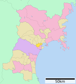
 Location of Rifu in Miyagi Prefecture |
|||
| Coordinates: 38°19′50″N 140°58′30″E / 38.33056°N 140.97500°ECoordinates: 38°19′50″N 140°58′30″E / 38.33056°N 140.97500°E | |||
| Country | Japan | ||
| Region | Tōhoku | ||
| Prefecture | Miyagi | ||
| District | Miyagi | ||
| Area | |||
| • Total | 44.89 km2 (17.33 sq mi) | ||
| Population (September 2015) | |||
| • Total | 354,769 | ||
| • Density | 797/km2 (2,060/sq mi) | ||
| Time zone | Japan Standard Time (UTC+9) | ||
| - Tree | Live oak | ||
| - Flower | Nashi pear | ||
| Phone number | 022-767-2111 | ||
| Address | Rifu Shinnamimatsu 4, Rifu-chō, Miyagi-gun, Miyagi-ken 981-0112 | ||
| Website | Official website | ||
Rifu (利府町 Rifu-chō?) is a town located in Miyagi District, Miyagi Prefecture, in the Tōhoku region of northern Japan. As of September 2015, the town had an estimated population of 35,769 and a population density of 797 persons per km². The total area was 44.89 square kilometres (17.33 sq mi). Rifu is known for its nashi pears. Recently, wine and candy made from nashi pears have been developed in the town.
Rifu is located in east-central Miyagi Prefecture, bordered by Sendai metropolis to the south and by Matsushima Bay to the east.
The area of present-day Rifu was part of ancient Mutsu Province, and has been settled since at least the Jomon period by the Emishi people. With the establishment of Tagajō in the Nara period, Rifu was part of the central Yamato colonization area in the region. During the Sengoku period, the area was contested by various samurai clans before the area came under the control of the Date clan of Sendai Domain during the Edo period, under the Tokugawa shogunate.
...
Wikipedia


