Ridley Creek
| Ridley Creek | |
|
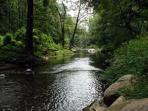
Ridley Creek flowing through Ridley Creek State Park
|
|
| Country | United States |
|---|---|
| State | Pennsylvania |
| Counties | Chester, Delaware |
| Source | |
| - location | Frazer, Chester County |
| - elevation | 2,180 ft (664 m) |
| - coordinates | 40°01′03″N 75°32′22″W / 40.01750°N 75.53944°W |
| Mouth | Delaware River |
| - location | Eddystone Borough, Delaware County |
| - coordinates | 39°50′59″N 75°20′38″W / 39.84972°N 75.34389°WCoordinates: 39°50′59″N 75°20′38″W / 39.84972°N 75.34389°W |
| Length | 23.4 mi (37.7 km) |
| Basin | 37.9 sq mi (98.2 km2) |
Ridley Creek is a tributary of the Delaware River in Chester and Delaware counties, Pennsylvania in the United States.
The entire drainage basin is in the suburban Philadelphia area, but the upper creek and extensive park lands on the creek retain a rural character, while the mouth of the creek has long been heavily industrialized. It was named for the parish of Ridley, Cheshire, England.
Two branches of the creek rise between Malvern and Frazer in Chester County, and then join about a mile south in Frazer. The creek flows south, then southeast to enter Delaware County and Ridley Creek State Park. Leaving the park, it passes the Tyler Arboretum and the town of Media, while entering a deep gorge. It passes local parks in Rose Valley and the Taylor Memorial Arboretum in Wallingford. Before flowing into the tidal Delaware River, it forms the border between the city of Chester and the borough of Eddystone.
The length from the confluence of the two branches to the mouth is about 22 miles (35 km); including the longer Northeast branch gives a length of about 23 miles (37 km).
...
Wikipedia


