Ridgeley, West Virginia
| Ridgeley, West Virginia | |
|---|---|
| Town | |

Ridgeley and the North Branch of the Potomac River, as viewed from Cumberland, Maryland, in 2007
|
|
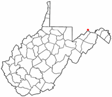
 Location of Ridgeley, West Virginia |
|
| Coordinates: 39°38′35″N 78°46′9″W / 39.64306°N 78.76917°WCoordinates: 39°38′35″N 78°46′9″W / 39.64306°N 78.76917°W | |
| Country | United States |
| State | West Virginia |
| County | Mineral |
| Government | |
| • Type | Mayor/council |
| • Mayor | Lynn Carr |
| • Council |
|
| Area | |
| • Total | 0.30 sq mi (0.78 km2) |
| • Land | 0.29 sq mi (0.75 km2) |
| • Water | 0.01 sq mi (0.03 km2) |
| Elevation | 699 ft (213 m) |
| Population (2010) | |
| • Total | 675 |
| • Estimate (2012) | 664 |
| • Density | 2,327.6/sq mi (898.7/km2) |
| Time zone | Eastern (EST) (UTC-5) |
| • Summer (DST) | EDT (UTC-4) |
| ZIP code | 26753 |
| Area code(s) | 304 |
| FIPS code | 54-68260 |
| GNIS feature ID | 1555480 |
Ridgeley is a town in Mineral County, West Virginia, United States, and part of the Cumberland Metropolitan Statistical Area. The population was 675 at the 2010 census.
Ridgeley was initially known as St. Clairsville, named for Sir John St Clair, Lt Colonel and Quartermaster General for the British General Edward Braddock. St Clair accompanied Braddock on his ill-fated march on Fort Duquesne and his disastrous defeat on July 9, 1755. It was incorporated as Ridgeley on November 28, 1914, named for the former owners of the land upon which the town was built.
Ridgeley is located at 39°38′35″N 78°46′9″W / 39.64306°N 78.76917°W (39.643187, -78.769189), along the North Branch of the Potomac River, opposite Cumberland, Maryland.
According to the United States Census Bureau, the town has a total area of 0.30 square miles (0.78 km2), of which, 0.29 square miles (0.75 km2) is land and 0.01 square miles (0.03 km2) is water.
The type locality of the Ridgeley Member of the Old Port Formation is located in the town. The Ridgeley name is given to local sandstone in honor of Ridgeley, WV, the far eastern boundary of the formation. It is primarily a sandstone, and is quarried locally.
...
Wikipedia
