Richmond, Michigan
| Richmond, Michigan | |
|---|---|
| City | |
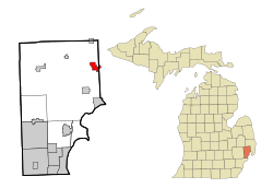
 Location of Richmond, Michigan |
|
| Coordinates: 42°48′42″N 82°45′24″W / 42.81167°N 82.75667°W | |
| Country | United States |
| State | Michigan |
| Counties | Macomb, St. Clair |
| Government | |
| • Mayor | Tim Rix |
| Area | |
| • Total | 2.89 sq mi (7.49 km2) |
| • Land | 2.85 sq mi (7.38 km2) |
| • Water | 0.04 sq mi (0.10 km2) |
| Elevation | 732 ft (223 m) |
| Population (2010) | |
| • Total | 5,735 |
| • Estimate (2012) | 5,740 |
| • Density | 2,012.3/sq mi (777.0/km2) |
| Time zone | Eastern (EST) (UTC-5) |
| • Summer (DST) | EDT (UTC-4) |
| ZIP code | 48062 |
| Area code(s) | 586 |
| FIPS code | 26-68380 |
| GNIS feature ID | 0635886 |
Richmond is a city on the border between Macomb and St. Clair counties within Metro Detroit and the U.S. state of Michigan. The population was 5,735 at the 2010 census. Most of the city is located in Macomb County, though there is a small portion in St. Clair County. The city is adjacent to Richmond Township and Lenox Township in Macomb County, although it is administratively autonomous. It is also adjacent to St. Clair County's Columbus Township and Casco Township.
According to the United States Census Bureau, the city has a total area of 2.89 square miles (7.49 km2), of which 2.85 square miles (7.38 km2) is land and 0.04 square miles (0.10 km2) is water.
As of the census of 2010, there were 5,735 people residing in the city. The population density was 2,012.3 inhabitants per square mile (777.0/km2). There were 2,479 housing units at an average density of 869.8 per square mile (335.8/km2). The racial makeup of the city was 94.2% White, 1.0% African American, 0.3% Native American, 0.2% Asian, 0.2% Pacific Islander, 2.6% from other races, and 1.5% from two or more races. Hispanic or Latino of any race were 4.6% of the population.
...
Wikipedia
