Richardson High School (Louisiana)
| West Monroe, Louisiana | |
|---|---|
| City | |

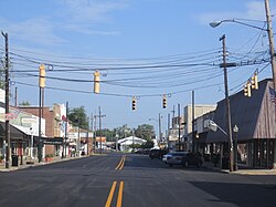
Cottonport Historic District in West Monroe
|
|
 Location of West Monroe in Ouachita Parish, Louisiana. |
|
 Location of Louisiana in the United States |
|
| Coordinates: 32°30′39″N 92°08′24″W / 32.51083°N 92.14000°WCoordinates: 32°30′39″N 92°08′24″W / 32.51083°N 92.14000°W | |
| Country | United States |
| State | Louisiana |
| Parish | Ouachita |
| Government | |
| • Mayor | Dave Norris |
| Area | |
| • Total | 8.28 sq mi (21.46 km2) |
| • Land | 8.00 sq mi (20.71 km2) |
| • Water | 0.29 sq mi (0.75 km2) |
| Elevation | 82 ft (25 m) |
| Population (2010) | |
| • Total | 13,065 |
| • Estimate (2016) | 12,922 |
| • Density | 1,616.26/sq mi (624.01/km2) |
| Time zone | CST (UTC-6) |
| • Summer (DST) | CDT (UTC-5) |
| Area code(s) | 318 |
| FIPS code | 22-80955 |
| Website | westmonroe.com |
West Monroe is a city in Ouachita Parish, Louisiana, United States. It is situated on the Ouachita River, across from the neighboring city of Monroe. The two cities are often referred to as the Twin Cities of northeast Louisiana. Its population was 13,065 at the 2010 census and it is part of the Monroe Metropolitan Statistical Area. The mayor, Dave Norris, a Democrat, has served since July 1, 1978, and was unopposed for a tenth term in the municipal election in 2014.
According to the United States Census Bureau, the city has a total area of 8.0 square miles (20.6 km²), of which 7.7 square miles (20.0 km²) is land and 0.2 square mile (0.6 km²) (3.14%) is water.
West Monroe is a separate municipality from Monroe.
As of the census of 2000, there were 13,250 people, 5,734 households, and 3,457 families residing in the city. The population density was 1,717.2 people per square mile (662.7/km²). There were 6,312 housing units at an average density of 818.1 per square mile (315.7/km²). The racial makeup of the city was 61.9% White, 33.6% African American, 0.4% Native American, 0.8% Asian, 0.05% Pacific Islander, 0.48% from other races, and 1.00% from two or more races. Hispanic or Latino of any race were 3.5% of the population.
...
Wikipedia
