Ribeira Quente
| Ribeira Quente | |
| Civil Parish | |
|
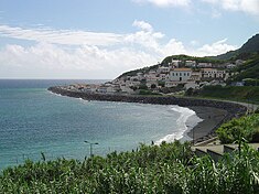
The locality of Fogo, the location of the parochial church, and behind the escarpment, the popular Fogo beach
|
|
| Official name: Freguesia de Ribeira Quente | |
| Name origin: Portuguese for hot ravine | |
| Country | |
|---|---|
| Autonomous Region | |
| Island | São Miguel |
| Municipality | Povação |
| Localities | Castelo, Eira das Freiras, Fogo, Ribeira Quente, Ponta da Albufeira, Ponta do Garajau |
| Landmark | Church of São Paulo |
| Rivers | Ribeira dos Tambores, Ribeira do Agrião |
| Center | Fogo |
| - elevation | 11 m (36 ft) |
| - coordinates | 37°43′50″N 25°18′25″W / 37.73056°N 25.30694°WCoordinates: 37°43′50″N 25°18′25″W / 37.73056°N 25.30694°W |
| Highest point | |
| - location | Pico dos Bodes |
| - elevation | 511 m (1,677 ft) |
| - coordinates | 37°45′2″N 25°17′24″W / 37.75056°N 25.29000°W |
| Lowest point | Sea Level |
| - location | Atlantic Ocean |
| - elevation | 0 m (0 ft) |
| Area | 9.04 km2 (3 sq mi) |
| Population | 767 (2011) |
| Density | 85/km2 (220/sq mi) |
| Settlement | fl. 1522 |
| - Parish | c. 1765 |
| - Civil Parish | 24 June 1943 |
| LAU | Junta Freguesia |
| - location | Rua Dr. Frederico Moniz Pereira |
| - elevation | 9 m (30 ft) |
| - coordinates | 37°44′7″N 25°17′53″W / 37.73528°N 25.29806°W |
| President Junta | Gualberto Costa Rita |
| President Assembleia | Rui Jorge Fravica Melo |
| Timezone | Azores (UTC-1) |
| - summer (DST) | Azores (UTC0) |
| Postal Zone | 9675-174 |
| Area Code & Prefix | (+351) 292 XX XX XX |
| Patron Saint | São Paulo |
| Website: http://www.ribeiraquente.com/junta.htm | |
Ribeira Quente is a civil parish in the municipality of Povoação in the Portuguese archipelago of the Azores. The population in 2011 was 767, in an area of 9.04 km². It is the smallest (by area), the lowest (by elevation) and the southernmost of the parishes in municipality.
Around the middle of the 15th century, the first settlers began occupying land along the coast of what would become Ribeira Quente. Sometime in 1588, a huge landslide from the valley of Furnas, provoked by intense rainfall, caused the expansion of the land in Ribeira Quente. A similar volcanic eruption on 2 September 1630, within the Furnas craters, also provoked a debris flow of debris, that inundated the river and covered the coast, limiting the access of local shipping that once crossed the area. It was within this problem environment that a small sedentary community continued occupy and develop along the coast. This community was populated by a poor peasant class, that includes generations of fishermen, for the greater part of its history. A local historian once described the heritage of this community, and particular, the rise of a few families:
Around 1765, the first chapel dedicated to São Paul was established by peoples from Vila Franca do Campo; at the time, Ribeira Quente was a parish within this municipality. A second temple was built around 1796-98, when the church did not provide sufficient space for the growing community, and after the original church was damaged due to its proximity to the sea.
The Fort of São Paulo was an important part of the communities defence during the era of piracy. Located west of Fogo beach, an area where privateers and pirates could easily disembark, the Fort was established in an area with high cliffs; by 1817 the Fort was in ruins and its artillery removed. In 1839, Ribeira Quente was integrated into the municipality of Povoação, which was obliged to construct a rudimentary road, the Caminho do Redondo, as part of its act of union with the municipality. It was during the visit of King Carlos I of Portugal that a stone marker was placed to commemorate the beginning of the construction of the access road: this project would only be completed 37 years later.
During the first half of the 20th century, one of the larger engineering projects carried out on the island of São Miguel was the construction of two tunnels (referred locally as the Tuneis de Liberidade) that linked Furnas to the southern village. The first tunnel was inaugurated in 1935, while the second occurred four years later. This marked the end of the community's isolation from the rest of the island; until this time, the village could only be accessed by dirt road, horse or cattle-carts (approximately 360 years since its founding). These project was part of a plan for greater economic and social development in the region, resulting in the re-qualification and improvements to roadlinks, and the expansion of the fishing port (which was completed in the middle of the century).
...
Wikipedia

