Rhodope prefecture
|
Rhodope Περιφερειακή ενότητα Ροδόπης |
|
|---|---|
| Regional unit | |

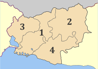
Municipalities of Rhodope
|
|
 Rhodope within Greece |
|
| Coordinates: 41°05′N 25°25′E / 41.083°N 25.417°ECoordinates: 41°05′N 25°25′E / 41.083°N 25.417°E | |
| Country | Greece |
| Region | East Macedonia and Thrace |
| Capital | Komotini |
| Area | |
| • Total | 2,543 km2 (982 sq mi) |
| Population (2011) | |
| • Total | 112,039 |
| • Density | 44/km2 (110/sq mi) |
| Postal codes | 69x xx |
| Area codes | 253x0 |
| ISO 3166 code | GR-73 |
| Car plates | ΚΟ |
Rhodope (Greek: Ροδόπη, Rodópi, [roˈðopi]) is one of the regional units of Greece. It is part of the region of East Macedonia and Thrace. Its name is derived from the Rhodope Mountains, which cover the northern part of its territory. Together with the regional units Evros and Xanthi, it forms the geographical region of Western Thrace. The capital of the prefecture is the city of Komotini. The second largest town is Sapes. Most of the Muslims of Thrace, the only officially recognized minority in Greece, are settled in this area, where they form around half of the population.
Rhodope borders on the regional unit Xanthi to the west and Evros to the east, and on Bulgaria's Kardzhali Province to the north. The Aegean Sea lies to the south. The eastern Rhodope Mountains cover the northern part of the regional unit. Apart from the mountainous areas, the territory consists mainly of farmland, forests and grasslands.
The southern and the central part have a mainly Mediterranean climate, and the northern part a mainly continental climate with cold winters.
The regional unit Rhodope is subdivided into 4 municipalities. These are (number as in the map in the infobox):
In 2015 this regional unit has three seats in the Hellenic Parliament.
...
Wikipedia
