Rhode Island Route 7
| Route 7 | ||||
|---|---|---|---|---|
| Douglas Pike | ||||
 |
||||
| Route information | ||||
| Maintained by RIDOT | ||||
| Length: | 15.7 mi (25.3 km) | |||
| Existed: | by 1934 – present | |||
| Major junctions | ||||
| South end: |
|
|||
|
|
||||
| North end: | Joslin Road in Burrillville | |||
| Location | ||||
| Counties: | Providence | |||
| Highway system | ||||
|
||||
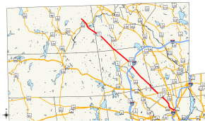
Route 7 is a numbered state highway in Rhode Island, United States. It runs approximately 16 miles (26 km) from Route 246 in Providence to Joslin Road in Burrillville.
Route 7 begins in Providence at an intersection with Route 246, carrying Orms Street in a western direction. As it passes over I-95, the route meets Douglas Avenue and turns onto it, flanking a residential area. It then enters North Providence and continues for another 1.5 miles (2.4 km), exiting the residential area at Wenscott Reservoir and entering Smithfield. On the reservoir, Route 7 crosses a causeway, becoming the Douglas Pike and retaining that name through the township. The road passes through a heavily wooded area, serving several homes in the area. It expands to four lanes for a short while as it features an interchange with I-295, passing by a shopping center and also intersecting Route 116. North of there, after thinning to two lanes once more, it intersects both Routes 5 and 104, forming a short concurrency with them as they cross each other in North Smithfield. The road continues north to Burrillville, passing through Nasonville, where it makes a right turn and momentarily changes name to Victory Highway; however, that road leaves at the very next intersection. As Douglas Turnpike again, the route crosses Route 102 and continues north to Joslin Road.
...
Wikipedia

