Rheinfelden, Germany
| Rheinfelden | ||
|---|---|---|

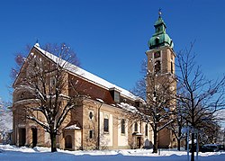
Saint Joseph Church
|
||
|
||
| Coordinates: 47°33′40″N 7°47′30″E / 47.56111°N 7.79167°ECoordinates: 47°33′40″N 7°47′30″E / 47.56111°N 7.79167°E | ||
| Country | Germany | |
| State | Baden-Württemberg | |
| Admin. region | Freiburg | |
| District | Lörrach | |
| Government | ||
| • Mayor | Eberhard Niethammer (CDU) | |
| Area | ||
| • Total | 62.84 km2 (24.26 sq mi) | |
| Population (2015-12-31) | ||
| • Total | 32,756 | |
| • Density | 520/km2 (1,400/sq mi) | |
| Time zone | CET/CEST (UTC+1/+2) | |
| Postal codes | 79618 | |
| Dialling codes | 07623 | |
| Vehicle registration | LÖ | |
| Website | www.rheinfelden-baden.de | |
Rheinfelden (Alemannic German: Badisch-Rhyfälde, pronounced [ˈb̥ad̥ɪʃ ʁifæld̥ə]) is a town in the district of Lörrach in Baden-Württemberg, Germany. It is situated on the right bank of the Rhine, across from Rheinfelden, Switzerland, and 15 km east of Basel. The population is 32,469 as of 2006, making it the second most populated town of the district after Lörrach.
Rheinfelden is located on the Swiss-German border, between the High Rhine to the south and the Dinkelberg hills to the north in the district of Lörrach. It borders the Swiss town of the same name across the Rhine river, and the towns of Grenzach-Wyhlen, Inzlingen, Steinen, Maulburg, Schopfheim, Schwörstadt, and Wehr in Germany.
Rheinfelden consists of a relatively young city core (founded in the late 19th Century), two formerly independent villages (Nollingen and Warmbach), and seven villages which were incorporated into the city between 1972 and 1975. These are:
Apart from the city core, the villages forming Rheinfelden date from the early Middle Ages. Partly because of this, a teasing animosity exists between the villages with their longer history and traditions, and the industrial city core with its diverse population of recent origin.
...
Wikipedia


