Reutenen
| Homburg | ||
|---|---|---|

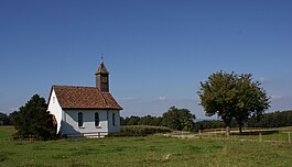
Chapel of St.Antonius, Salen-Reutenen
|
||
|
||
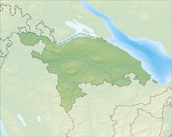
| Coordinates: 47°38′N 9°1′E / 47.633°N 9.017°ECoordinates: 47°38′N 9°1′E / 47.633°N 9.017°E | ||
| Country | Switzerland | |
| Canton | Thurgau | |
| District | Frauenfeld | |
| Area | ||
| • Total | 24.13 km2 (9.32 sq mi) | |
| Elevation | 591 m (1,939 ft) | |
| Population (Dec 2016) | ||
| • Total | 1,537 | |
| • Density | 64/km2 (160/sq mi) | |
| Postal code | 8508 | |
| SFOS number | 4816 | |
| Surrounded by | Herdern, Mammern, Müllheim, Pfyn, Raperswilen, Steckborn, Wigoltingen | |
| Website |
www SFSO statistics |
|
Homburg is a municipality in Frauenfeld District in the canton of Thurgau in Switzerland.
Homburg is first mentioned in 899 as Hohenperc. In 1243 it was mentioned as de Honburch. From the Middle Ages until 1798 it was part of the lands of Klingenberg Castle. Between 1651 and 1798, Muri Abbey held the Herrschaft rights and they granted the low court to their governor who lived at the castle. The parish of Homburg covered the same land as the Herrschaft. After the Protestant Reformation of 1528, in 1532 the old faith was restored. Both faiths used the same church until the 1555/56 when the Reformed worship was ended. In the 19th century livestock, dairy farming and fruit production began to replace agriculture. The dairy cooperative building was built in 1866-67. Despite the a small industry base, Herzog Küchen AG, and the construction of some houses Homburg has remained a farming village.
Homburg has an area, as of 2009[update], of 24.15 square kilometers (9.32 sq mi). Of this area, 16.88 km2 (6.52 sq mi) or 69.9% is used for agricultural purposes, while 5.81 km2 (2.24 sq mi) or 24.1% is forested. Of the rest of the land, 1.36 km2 (0.53 sq mi) or 5.6% is settled (buildings or roads), 0.03 km2 (7.4 acres) or 0.1% is either rivers or lakes and 0.02 km2 (4.9 acres) or 0.1% is unproductive land.
Of the built up area, industrial buildings made up 3.0% of the total area while housing and buildings made up 0.2% and transportation infrastructure made up 0.3%. while parks, green belts and sports fields made up 2.2%. Out of the forested land, all of the forested land area is covered with heavy forests. Of the agricultural land, 65.1% is used for growing crops, while 4.8% is used for orchards or vine crops. All the water in the municipality is flowing water. Of the unproductive areas, and .
...
Wikipedia


