Reusel-De Mierden
| Reusel-De Mierden | |||
|---|---|---|---|
| Municipality | |||

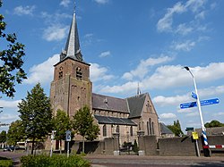
Church in Lage Mierde
|
|||
|
|||
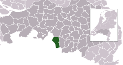
 Location in North Brabant |
|||
| Coordinates: 51°22′N 5°10′E / 51.367°N 5.167°ECoordinates: 51°22′N 5°10′E / 51.367°N 5.167°E | |||
| Country | Netherlands | ||
| Province | North Brabant | ||
| Established | 1 January 1997 | ||
| Government | |||
| • Body | Municipal council | ||
| • Mayor | Harrie Tuerlings (CDA) | ||
| Area | |||
| • Total | 78.64 km2 (30.36 sq mi) | ||
| • Land | 77.93 km2 (30.09 sq mi) | ||
| • Water | 0.71 km2 (0.27 sq mi) | ||
| Elevation | 32 m (105 ft) | ||
| Population (February 2017) | |||
| • Total | 12,759 | ||
| • Density | 164/km2 (420/sq mi) | ||
| Time zone | CET (UTC+1) | ||
| • Summer (DST) | CEST (UTC+2) | ||
| Postcode | 5094–5096, 5540–5541 | ||
| Area code | 013, 0497 | ||
| Website | www |
||
Reusel-De Mierden (![]() pronunciation ) is a municipality in the southern Netherlands. It is located in the North Brabant province, and has an area of 78.64 km2 (30.36 sq mi). It had a population of 12,759 in 2017.
pronunciation ) is a municipality in the southern Netherlands. It is located in the North Brabant province, and has an area of 78.64 km2 (30.36 sq mi). It had a population of 12,759 in 2017.
Dutch Topographic map of the municipality of Reusel-De Mierden, June 2015
Reusel-De Mierden erroneously appears in more than a million family trees as a place of origin or residence. This is due to a software error that changed "Holland" to "Reusel-De Mierden, Noord-Brabant, Netherlands."
...
Wikipedia


