Republic, Ohio
| Republic, Ohio | |
|---|---|
| Village | |

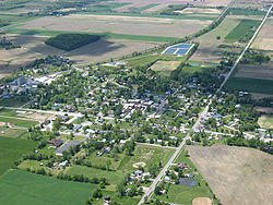
Aerial view of Republic
|
|
 Location of Republic, Ohio |
|
 Location of Republic in Seneca County |
|
| Coordinates: 41°7′18″N 83°1′3″W / 41.12167°N 83.01750°WCoordinates: 41°7′18″N 83°1′3″W / 41.12167°N 83.01750°W | |
| Country | United States |
| State | Ohio |
| County | Seneca |
| Government | |
| • Type | Village council |
| • Mayor | Jeff L. Larick |
| Area | |
| • Total | 0.86 sq mi (2.23 km2) |
| • Land | 0.86 sq mi (2.23 km2) |
| • Water | 0 sq mi (0 km2) |
| Elevation | 879 ft (268 m) |
| Population (2010) | |
| • Total | 549 |
| • Estimate (2012) | 538 |
| • Density | 638.4/sq mi (246.5/km2) |
| Time zone | Eastern (EST) (UTC-5) |
| • Summer (DST) | EDT (UTC-4) |
| ZIP code | 44867 |
| Area code(s) | 419 |
| FIPS code | 39-66320 |
| GNIS feature ID | 1061596 |
Republic is a village in Seneca County, Ohio, United States. The population was 549 at the 2010 census.
In 1834, Sidney Smith hired R.M. Shoemaker of Cincinnati to survey a new town at the corners of sections 15, 16, 21, and 22 in Scipio Township. He called it "Republic," though it was known by many early settlers simply as "Scipio Center."
With the arrival of a rail line from Sandusky in 1841, Republic became a popular trading center. Stores, warehouses, shops, and factories sprang up almost overnight. And, a second rail line was contemplated between Republic and Melmore in Eden Township.
When the old Seneca County courthouse at Tiffin burned on May 21, 1841, efforts were made to establish the new county seat at Republic.
Republic's fortunes began to decline when the new Cincinnati, Sandusky & Cleveland Railroad bypassed it to make a straight run to Tiffin, although it experienced something of a revival with the coming of the Baltimore and Ohio Railroad. The railroad passes over State Route 19 via an arch bridge.
Republic is located at 41°7′18″N 83°1′3″W / 41.12167°N 83.01750°W (41.121793, -83.017478).
According to the United States Census Bureau, the village has a total area of 0.86 square miles (2.23 km2), all land.
As of the census of 2010, there were 549 people, 220 households, and 151 families residing in the village. The population density was 638.4 inhabitants per square mile (246.5/km2). There were 245 housing units at an average density of 284.9 per square mile (110.0/km2). The racial makeup of the village was 98.2% White, 0.4% African American, 0.5% Native American, 0.2% Asian, and 0.7% from two or more races. Hispanic or Latino of any race were 1.8% of the population.
...
Wikipedia
