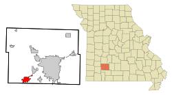
Republic, Missouri
| Republic, Missouri | |
|---|---|
| City | |
 Location of Republic, Missouri |
|
| Coordinates: 37°7′18″N 93°28′17″W / 37.12167°N 93.47139°WCoordinates: 37°7′18″N 93°28′17″W / 37.12167°N 93.47139°W | |
| Country | United States |
| State | Missouri |
| Counties | Christian, Greene |
| Area | |
| • Total | 13.31 sq mi (34.47 km2) |
| • Land | 13.30 sq mi (34.45 km2) |
| • Water | 0.01 sq mi (0.03 km2) |
| Elevation | 1,309 ft (399 m) |
| Population (2010) | |
| • Total | 14,751 |
| • Estimate (2015) | 16,005 |
| • Density | 1,109.1/sq mi (428.2/km2) |
| Time zone | Central (CST) (UTC-6) |
| • Summer (DST) | CDT (UTC-5) |
| ZIP code | 65738 |
| Area code(s) | 417 |
| FIPS code | 29-61238 |
| GNIS feature ID | 0725224 |
| Website | City Website |
Republic is a city in Christian and Greene counties in the U.S. state of Missouri. As of the 2010 census, the city population was 14,751. As of 2015, the population was 16,005. (Census Bureau Estimate) It is part of the Springfield, Missouri, Metropolitan Statistical Area.
Early settlement in southwest Greene County centered on the community of Little York. When the Frisco Railroad built a line in the area in 1872, Little York was not on the route. Settlement moved two miles away to Brookline which was on the rail line's route. The first plat for what is now Republic was filed 8 January 1879. While the railroad did go through Republic, there initially was no switch or depot located in the city. A public subscription of $1000 raised the funds to build a depot in the city. Subsequent growth is attributed to the depot's completion.
In 2005, the cities of Republic and Brookline consolidated as Missouri State laws allow after a vote of the residents of both communities approved the consolidation with Republic taking over all aspects of city government. Originally, Brookline was to retain its own identity, but the city limit signs have since been changed to Republic's. However, according to Section I (b) of the Intergovernmental Agreement:
"Name of Consolidated Municipality - The name of the consolidated municipality shall be "City of Republic." To help preserve the identity of the Village, the City will place signs with text “Village of Brookline” at the current corporate limits of the Village. Placement of signage is subject to State sign regulations when placed in State right-of-way. The City of Republic will work with the United States Postal Service to help preserve the history and operation of the Brookline Station Post Office."
Therefore, Brookline has retained its identity per intergovernmental agreement although city limit signs have been placed at the old borders of the village. The Brookline signs are still located to identify the original village area near the post office.
...
Wikipedia
