Renningen
| Renningen | ||
|---|---|---|

Town centre
|
||
|
||
| Coordinates: 48°45′58″N 8°56′5″E / 48.76611°N 8.93472°ECoordinates: 48°45′58″N 8°56′5″E / 48.76611°N 8.93472°E | ||
| Country | Germany | |
| State | Baden-Württemberg | |
| Admin. region | Stuttgart | |
| District | Böblingen | |
| Government | ||
| • Mayor | Wolfgang Faißt | |
| Area | ||
| • Total | 31.13 km2 (12.02 sq mi) | |
| Elevation | 409 m (1,342 ft) | |
| Population (2015-12-31) | ||
| • Total | 17,107 | |
| • Density | 550/km2 (1,400/sq mi) | |
| Time zone | CET/CEST (UTC+1/+2) | |
| Postal codes | 71264–71272 | |
| Dialling codes | 07159 | |
| Vehicle registration | BB, LEO | |
| Website | www.renningen.de | |
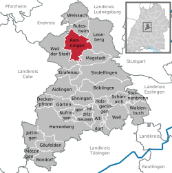
Renningen is a town in the district of Böblingen, Baden-Württemberg, Germany. It is situated 18 km west of Stuttgart.
Renningen is located in the west of Stuttgart, between Leonberg and Weil der Stadt on the fringes of the fertile plains of the Neckarland. The Rankbach valley extends here to the Renningen Basin.
Magstadt, Weil der Stadt, Leonberg, Rutesheim, Heimsheim
Renningen lies in an area which even in the Early Stone Age was thickly populated. Proof of this are the many remains found of settlements from the linear pottery culture. Remains of settlements found to originate with the Urnenfelderkultur (c. 1000 BC) as well the Hallstatt- and La Tène culture (Early to Late Iron Age), provide evidence of settlement during various prehistoric eras.
The evaluation of archeological digs and finds show expansion of two early Alemannic settlements within the Renningen Basin north and south of the Rankbach. Excavations by the then State Office for Historical Monuments in Baden-Württemberg in the Raite Industrial Park (1991) unearthed a number of farmsteads comprising three-naved longhouses, storehouses and pit houses (4th and 5th century).
A second settlement in the Neuwiesenäckern developed into a large settlement, which can now be identified as Altheim, first mentioned in the 12th century. During the Middle Ages, numerous other areas of settlement sprang up alongside this settlement. In the 12th and 13th century the population began to gravitate towards the two present-day centres of the town, since around 1200 the expansion of the outlying areas of the town seems to have stopped. Several earlier finds in the centre of Renningen show, that an older core settlement exists on the site of the later village. A few finds belong to the late Merovingian period or the Carolingian period, but most of the finds date to the 11th or 12th century and are contemporary with the settlements on the Neuwiesenäckern. It is however uncertain if the site had been occupied during the centuries between. Near the church there is a graveyard from the early Merovingian era excavated in 1989/90 by the State Office for Historical Monuments, which was abandoned c. 500 though it is questionable as to whether it served an actual settlement, since the only evidence for this is a single fragment of pottery found in the vicinity. Later burial sites have been found on only the south side of Malmheim, on the site of a suspected early Merovingian graveyard.
...
Wikipedia


