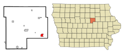
Reinbeck, Iowa
| Reinbeck, Iowa | |
|---|---|
| City | |
 Location of Reinbeck, Iowa |
|
| Coordinates: 42°19′20″N 92°35′55″W / 42.32222°N 92.59861°WCoordinates: 42°19′20″N 92°35′55″W / 42.32222°N 92.59861°W | |
| Country |
|
| State |
|
| County | Grundy |
| Area | |
| • Total | 1.82 sq mi (4.71 km2) |
| • Land | 1.82 sq mi (4.71 km2) |
| • Water | 0 sq mi (0 km2) |
| Elevation | 961 ft (293 m) |
| Population (2010) | |
| • Total | 1,664 |
| • Estimate (2012) | 1,654 |
| • Density | 914.3/sq mi (353.0/km2) |
| Time zone | Central (CST) (UTC-6) |
| • Summer (DST) | CDT (UTC-5) |
| ZIP code | 50669 |
| Area code(s) | 319 |
| FIPS code | 19-66315 |
| GNIS feature ID | 0460580 |
Reinbeck is a city in Grundy County, Iowa, United States. The population was 1,664 at the 2010 census—a five percent decrease from the population of 1,751 at the 2000 census. It is part of the Waterloo–Cedar Falls Metropolitan Statistical Area and is in the Cedar Valley.
Reinbeck is located at 42°19′20″N 92°35′55″W / 42.32222°N 92.59861°W (42.322218, -92.598696), along Iowa Highway 175.
According to the United States Census Bureau, the city has a total area of 1.82 square miles (4.71 km2), all of it land.
Reinbeck is host to a golf course, various sports fields, a bike trail and hunting range, and a swimming pool. The pool features a zero depth entry zone, a high board and a low board, a water slide, in addition to changing rooms and a concession stand.
As of the census of 2010, there were 1,664 people, 738 households, and 468 families residing in the city. The population density was 914.3 inhabitants per square mile (353.0/km2). There were 802 housing units at an average density of 440.7 per square mile (170.2/km2). The racial makeup of the city was 98.7% White, 0.2% African American, 0.1% Native American, 0.1% Asian, 0.5% from other races, and 0.4% from two or more races. Hispanic or Latino of any race were 1.1% of the population.
...
Wikipedia
