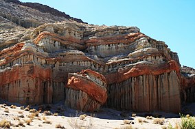
Red Rock Canyon State Park (California)
| Red Rock Canyon State Park | |
|---|---|
 |
|
| Location | Kern County, California, USA |
| Nearest city | Cantil, California |
| Coordinates | 35°22′22.75″N 117°59′26.47″W / 35.3729861°N 117.9906861°WCoordinates: 35°22′22.75″N 117°59′26.47″W / 35.3729861°N 117.9906861°W |
| Area | 27,000 acres (110 km2) |
| Established | 1968 |
| Governing body | California Department of Parks and Recreation |
Red Rock Canyon State Park features scenic desert cliffs, buttes and spectacular rock formations. The park is located where the southernmost tip of the Sierra Nevada converges with the El Paso Mountains.
Each tributary canyon is unique, with vivid colors. After wet winters, the park's floral displays are notable. Wildlife includes roadrunners, hawks, lizards, mice and squirrels.
Red Rock Canyon is an approximately 27,000 acres (110 km2) unit within the Mojave Sector of the Tehachapi District of the California State Park System, located along State Highway 14 in Kern County, about 80 miles (129 km) east of Bakersfield and 25 miles (40 km) north of Mojave. Red Rock Canyon provides magnificent views of the pristine desert landscape, includes two natural preserves, and offers, among other recreation activities, camping, sightseeing, equestrian activities, hiking, and opportunities for reflection and solitude.
The park is located on State Route 14, which connects U.S. Route 395 with the communities of Southern California, where 14 is known as the Antelope Valley Freeway. The park is 25 miles (40 km) northeast of Mojave on SR 14. SR 14 goes through the center of the park, in the canyon itself. No motorist/tourist facilities are available. It is not far from Cantil, California. Camping, picnic, and restroom facilities are available in several sites immediately off of California Route 14.
...
Wikipedia


