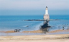
Rattray Head

Rattray Head Lighthouse
|
|
|
Scotland
|
|
| Location | Rattray Head Buchan Aberdeenshire Scotland |
|---|---|
| Coordinates | 57°36′36″N 1°49′00″W / 57.610123°N 1.816557°W |
| Year first constructed | 1895 |
| Automated | 1982 |
| Foundation | granite basement |
| Construction | brick tower |
| Tower shape | cylindrical tower with balcony and lantern on a conical frustum basement |
| Markings / pattern | unpainted basement, white tower, black lantern |
| Height | 34 metres (112 ft) |
| Focal height | 28 metres (92 ft) |
| Light source | solar power |
| Intensity | 156,000 candela |
| Range | 24 nautical miles (44 km; 28 mi) |
| Characteristic | Fl (3) W 30s. |
| Fog signal | 2 blasts every 45s. |
| Admiralty number | A3304 |
| NGA number | 2776 |
| ARLHS number | SCO-179 |
| Managing agent | Rattray Head B&B and Ratty's Tearoom |
Rattray Head (![]() listen ), historically Rattray Point, is a headland in Buchan, Aberdeenshire, on the north-east coast Scotland. To north lies Strathbeg Bay and Rattray Bay is to its south. The dunes at Rattray Head beach can be up to 75 feet (23 m) high and stretch 17 miles (27 km) from St Combs to Peterhead.
listen ), historically Rattray Point, is a headland in Buchan, Aberdeenshire, on the north-east coast Scotland. To north lies Strathbeg Bay and Rattray Bay is to its south. The dunes at Rattray Head beach can be up to 75 feet (23 m) high and stretch 17 miles (27 km) from St Combs to Peterhead.
The 120-foot (37 m) Rattray Head lighthouse was built in 1895. It was built by the engineers and brothers David Alan Stevenson and Charles Alexander Stevenson. In February 1982 it became unmanned and self-working.
The lighthouse is accessible by way of a causeway that is usually underwater being only visible at low tide. It is wide enough for a vehicle to cross.
Remains of several shipwrecks can still be seen on the beach.
Coordinates: 57°36′43″N 1°49′27″W / 57.61187°N 1.82425°W
...
Wikipedia

