Ratliff City, Oklahoma
| Ratliff City, Oklahoma | |
|---|---|
| Town | |
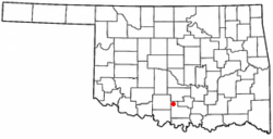
 Location of Ratliff City, Oklahoma |
|
| Coordinates: 34°26′56″N 97°30′40″W / 34.44889°N 97.51111°WCoordinates: 34°26′56″N 97°30′40″W / 34.44889°N 97.51111°W | |
| Country | United States |
| State | Oklahoma |
| County | Carter |
| Area | |
| • Total | 1.1 sq mi (2.9 km2) |
| • Land | 1.1 sq mi (2.9 km2) |
| • Water | 0.0 sq mi (0.0 km2) |
| Elevation | 1,043 ft (318 m) |
| Population (2010) | |
| • Total | 120 |
| • Density | 107/sq mi (41.4/km2) |
| Time zone | Central (CST) (UTC-6) |
| • Summer (DST) | CDT (UTC-5) |
| ZIP code | 73481 |
| Area code(s) | 580 |
| FIPS code | 40-61900 |
| GNIS feature ID | 1097051 |
Ratliff City is a town in Carter County, Oklahoma, United States. The population was 120 at the 2010 census. Ratliff City was named for Ollie Ratliff, owner of a local garage. It is part of the Ardmore, Oklahoma Micropolitan Statistical Area.
The post office was opened on January 1, 1953, when the town was incorporated.
Ratliff City is located in northwestern Carter County at 34°26′56″N 97°30′40″W / 34.44889°N 97.51111°W (34.448918, -97.510999).
Ratliff City is located at the junction of State Highways 7 and 76. Highway 7 leads east 24 miles (39 km) to Davis and west 27 miles (43 km) to Duncan, while Highway 76 leads north 12 miles (19 km) to Foster and south 15 miles (24 km) to Healdton.
According to the United States Census Bureau, Ratliff City has a total area of 1.1 square miles (2.9 km2), all of it land.
As of the census of 2000, there were 131 people, 53 households, and 41 families residing in the town. The population density was 116.6 people per square mile (45.2/km²). There were 70 housing units at an average density of 62.3 per square mile (24.1/km²). The racial makeup of the town was 87.79% White, 1.53% African American, 5.34% Native American, and 5.34% from two or more races.
...
Wikipedia
