Rapperswil, St. Gallen
| Rapperswil | ||
|---|---|---|
| Former municipality of Switzerland | ||

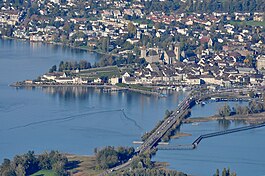
Rapperswil as seen from Etzel mountain: Capuchin monastery to the left, Rapperswil castle and St. John's church in the background, Lake Zürich harbour and Altstadt in the foreground respectively Seedamm, wooden bridge and upper Lake Zürich to the right (October 2010)
|
||
|
||
| Coordinates: 47°13.6′N 8°49′E / 47.2267°N 8.817°ECoordinates: 47°13.6′N 8°49′E / 47.2267°N 8.817°E | ||
| Country | Switzerland | |
| Canton | St. Gallen | |
| District | See-Gaster | |
| Municipality | Rapperswil-Jona | |
| Government | ||
| • Mayor | Stadtpräsident/Stadtammann (list) | |
| Area | ||
| • Total | 1.74 km2 (0.67 sq mi) | |
| Elevation | 409 m (1,342 ft) | |
| Population (December 2006) | ||
| • Total | 7,601 | |
| • Density | 4,400/km2 (11,000/sq mi) | |
| Postal code | 8640 | |
| SFOS number | 3316 | |
| Surrounded by | Altendorf (SZ), Freienbach (SZ), Jona, Bollingen, Lachen (SZ) | |
| Website |
www SFSO statistics |
|
| Lordship (County) of Rapperswil | ||||||||||
| Herrschaft (Grafschaft) Rapperswil | ||||||||||
| State of the Holy Roman Empire | ||||||||||
|
||||||||||
| Capital | Rapperswil | |||||||||
| Government | Principality | |||||||||
| Historical era | Middle Ages, Early Modern period | |||||||||
| • | Rapperswil founded | 1229 (official date) | ||||||||
| • | Lordship established | ca 1233 1220 | ||||||||
| • | Inherited by counts of Habsburg-Laufenburg |
1309–58 |
||||||||
| • | Purchased liberty from Austria |
1415–58 |
||||||||
| • | Allied with Habsburg and Zürich in the Old Zürich War |
1440–46 |
||||||||
| • |
Condominium of the Old Swiss Confederacy |
1458–1798 |
||||||||
| • |
Annexed to Helvetic canton of Linth |
1798 1464 |
||||||||
| • | Joined St Gallen | February 19, 1803 | ||||||||
|
||||||||||
Rapperswil (Swiss German: [ˈrɑpːərʃˌʋiːl] or [ˈrɑpːərsˌʋiːl]; short: Rappi) is a former municipality and since January 2007 part of the municipality of Rapperswil-Jona in the Wahlkreis (constituency) of See-Gaster in the canton of St. Gallen in Switzerland, located at the east side of the Lake Zurich.
The town's main sights are concentrated in the Altstadt of Rapperswil and can be seen while strolling through the medieval alleys. The main sights of Rapperswil are its rose gardens, Rapperswil Castle, the reconstructed wooden bridge to Hurden with its bridge chapel Heilig Hüsli located at Seedamm, the Kapuzinerkloster (Capuchin's monastery), the remains of the Middle Ages fortifications located on Lake Zürich, Lindenhof hill, Herrenberg, Engelplatz, Hauptplatz, Bühlerallee and Fischmarktplatz at Rapperswil harbour.
Rapperswil is often referred to as the "town of roses" (Rosenstadt) because of its extensive displays of roses in three designated parks. No less than 15,000 plants of 600 different kinds may be viewed between June and October. There is also a rose garden in the town center, accessible to blind and disabled people.
...
Wikipedia


