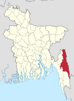
Rangamati District
|
Rangamati 1860 Rangamattye |
|
|---|---|
 |
|
| Coordinates: 22°38′N 92°12′E / 22.633°N 92.200°ECoordinates: 22°38′N 92°12′E / 22.633°N 92.200°E | |
| Country |
|
| Division | Chittagong Division |
| District | Rangamati District |
| Government | |
| • Member of the Parliament from Rangamati Hill District | Ushatan Talukder (Chakma) |
| • Deputy Commissioner(DC) & District Magistrate(DM) | Md. Shamsul Arefin |
| • Chakma Raja (Chakma Circle Chief) | Debashish Roy |
| • Pouroshava Mayor | Akbar Hossain Chowdhury |
| Area | |
| • Total | 6,116.11 km2 (2,361.44 sq mi) |
| • Land | 4,824.63 km2 (1,862.80 sq mi) |
| • Water | 1,291.5 km2 (498.7 sq mi) |
| Elevation | 17 m (56 ft) |
| Population (2011 census) | |
| • Total | 595,979 |
| • Density | 97/km2 (250/sq mi) |
| Time zone | BST (UTC+6) |
| Postal Code | 4500 |
| Area code(s) | 0351 |
| Population & Area related info taken from রাঙ্গামাটি জেলা তথ্য বাতায়নে আপনাকে স্বাগতম [Welcome to the Rangamati district portal]. Deputy Commissioner Rangamati (in Bangla). Archived from the original on 2013-01-17. | |
