Rancho Palos Verdes, California
| Rancho Palos Verdes, California | ||
|---|---|---|
| City | ||
| City of Rancho Palos Verdes | ||

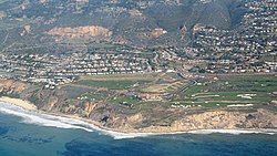
Aerial view of Trump National Golf Club
|
||
|
||
| Nickname(s): RPV | ||
 Location of Rancho Palos Verdes in Los Angeles County, California |
||
| Location in the United States | ||
| Coordinates: 33°45′30″N 118°21′51″W / 33.75833°N 118.36417°WCoordinates: 33°45′30″N 118°21′51″W / 33.75833°N 118.36417°W | ||
| Country | ||
| State |
|
|
| County |
|
|
| Incorporated | September 7, 1973 | |
| Government | ||
| • Mayor | Brian Campbell | |
| Area | ||
| • Total | 13.465 sq mi (34.875 km2) | |
| • Land | 13.465 sq mi (34.874 km2) | |
| • Water | 0 sq mi (0.001 km2) 0% | |
| Elevation | 220 ft (67 m) | |
| Population (April 1, 2010) | ||
| • Total | 41,643 | |
| • Estimate (2013) | 42,448 | |
| • Density | 3,100/sq mi (1,200/km2) | |
| Time zone | Pacific (UTC-8) | |
| • Summer (DST) | PDT (UTC-7) | |
| ZIP code | 90275 | |
| Area code(s) | 310/424 | |
| FIPS code | 06-59514 | |
| GNIS feature IDs | 255967, 2411516 | |
| Website | rpvca |
|
Rancho Palos Verdes (also known by the abbreviation RPV) is a city in Los Angeles County, California atop the Palos Verdes Hills and bluffs of the Palos Verdes Peninsula. An affluent suburb of Los Angeles, it is known for large tracts of open space and expansive views of the Pacific Ocean. Rancho Palos Verdes is translated as "Ranch of Green Sticks", probably referring to the willows in the northeastern part of Bixby Slough (now known as Machado Lake) shown on earlier maps.
The history of Rancho Palos Verdes dates back to the Tongva or Gabrielino Indians, who inhabited the site before the Age of Discovery. Portuguese explorer Juan Rodriguez Cabrillo was credited as the first European to navigate the California Coast in 1542, which included the hills of Rancho Palos Verdes. Rancho de los Palos Verdes was established by a Mexican land grant given in 1846 by Governor Pio Pico to Jose Loreto and Juan Capistrano Sepulveda.
The city's most notable geographic features are the Palos Verdes Hills and cliffs, with grand vistas of the Pacific Ocean and of Santa Catalina Island. The city incorporated on September 7, 1973. The population was 41,643 at the 2010 census.
The Point Vicente Interpretive Center is a premier whale-watching site provides spectacular opportunities to view the annual migration of the Pacific gray whale from December through April. The center opened in 1984 with a mission to present and interpret the unique features and history of the Palos Verdes Peninsula. The almost 10,000-square-foot (930 m2) expanded Interpretive Center, reopened on July 15, 2006, features exhibits on the natural and cultural history of the peninsula, with a special emphasis on the Pacific gray whale. The Point Vicente Lighthouse, built in 1926, is adjacent to the center and is on the National Register of Historic Places. At another location along the coast, Wayfarers Chapel, designed by Lloyd Wright and built between 1949 and 1951, is also on the National Register of Historic Places.
...
Wikipedia


