Rancho Murieta
| Rancho Murieta | |
|---|---|
| census-designated place | |
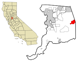
 Location in Sacramento County and the state of California |
|
| Coordinates: 38°30′11″N 121°5′5″W / 38.50306°N 121.08472°WCoordinates: 38°30′11″N 121°5′5″W / 38.50306°N 121.08472°W | |
| Country |
|
| State |
|
| County | Sacramento |
| Area | |
| • Total | 12.068 sq mi (31.255 km2) |
| • Land | 11.887 sq mi (30.787 km2) |
| • Water | 0.181 sq mi (0.468 km2) 1.50% |
| Elevation | 167 ft (51 m) |
| Population (2010) | |
| • Total | 5,488 |
| • Density | 450/sq mi (180/km2) |
| Time zone | PST (UTC-8) |
| • Summer (DST) | PDT (UTC-7) |
| ZIP code | 95683 |
| Area code(s) | 916 |
| FIPS code | 06-59506 |
| GNIS feature ID | 1820537 |
Rancho Murieta is a census-designated place (CDP) and guard-gated community in Sacramento County, California, United States. It is part of the Sacramento–Arden-Arcade–Roseville Metropolitan Statistical Area. The population was 5,488 at the 2010 census, up from 4,193 at the 2000 census. It is located in the foothills of the Sierra Nevada range, about 25 miles (40 km) east of Sacramento.
Rancho Murieta is located at 38°30′11″N, 121°5′5″W (38.503068, -121.084643)GR1.
According to the United States Census Bureau, the CDP has a total area of 12.1 square miles (31 km2), of which, 11.9 square miles (31 km2) of it is land and 0.2 square miles (0.52 km2) of it (1.50%) is water. The principal east-west access route is California State Highway 16, the Jackson Highway, which connects Rancho Murieta with the Sacramento metropolitan area.
The 2010 United States Census reported that Rancho Murieta had a population of 5,488. The population density was 454.8 people per square mile (175.6/km²). The racial makeup of Rancho Murieta was 4,874 (88.8%) White, 130 (2.4%) African American, 33 (0.6%) Native American, 158 (2.9%) Asian, 6 (0.1%) Pacific Islander, 81 (1.5%) from other races, and 206 (3.8%) from two or more races. Hispanic or Latino of any race were 425 persons (7.7%).
...
Wikipedia
